
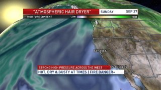
In late September as storms typically miss us to the north and strong high pressure builds afterwards, it sets the stage for what is typically our most extreme time of year for fire danger in the Bay Area and the rest of California.
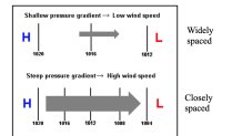
It’s all about the wind.
Think of high pressure as a region of sinking warm drying air aloft, not only does it bring hot weather but usually involves north to offshore winds also known as “Diablo Winds” out of the east, sinking warming and drying the air down to sea level pushing the cooler marine air offshore.
This offshore winds can come in a couple of varieties ... strong high pressure as we’re seeing now or via high pressure and strong low pressure nearby usually dropping down near or east of the Sierra (aka inside slider storms) where the pressure gradient between high pressure and low pressure results in higher wind speeds.
Where the atmospheric river is a stream of high moisture value tropical air, this pattern is quite its opposite for the net drying and warming effects it has on local weather, hence a term I’ve used “hair dryer” for its similar effects.
California
News from across California

As this year’s record breaking fire season continues, from a climatology standpoint we need to be prepared that October usually does involve the highest fire danger weeks and driest time of year with these offshore winds.
This year perhaps more than any other we’re hopeful the rainy season makes an early return.
