
What to Know
- Storms will arrive as holiday traveler hit the roads in California.
- Northern California will see rain and snow Tuesday through Sunday.
- In Southern California, rain is in the forecast for Thursday with another system arriving Saturday.
Holiday travelers are facing a stormy week in California
Mountain snowfall and widespread rain are in this week's forecast as a parade of precipitation moves toward the state. The first wave of rain and snow arrived Wednesday morning in Northern California, That system is expected to wallop Southern California Thursday into Friday.
Here's the storm outlook. This article will be updated throughout the week.
Get Southern California news, weather forecasts and entertainment stories to your inbox. Sign up for NBC LA newsletters.

Holiday Weather in Northern California
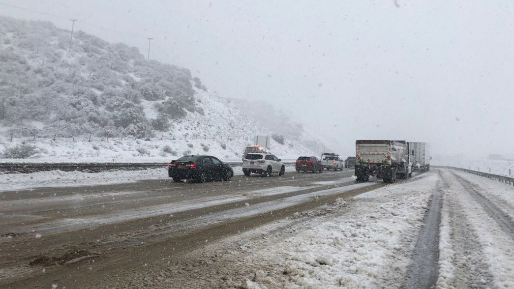
Snow and rain are falling in Northern California, and that weather pattern will continue through Sunday. Part of the Sierra Nevada Mountain range will see 1 to 5 feet of snow, possibly up to 8 feet at higher elevations.
Chain requirements were already in effect for vehicles on some stretches of routes through the Sierra Nevada Mountains.
Communities at lower elevations also can expect significant snow, including over the 5 Freeway of Redding. Storms in that area earlier this month shut down the highway for nearly 24 hours.
Little break in snowfall is expected after Tuesday, and gusty winds will only make travel more difficult in the mountains. Rainfall was light to moderate around the San Francisco Bay Area Wednesday as the system slowly spread down the coast.
Holiday Weather in Southern California
The wet weather pattern will affect Southern California by mid-week and bring rain and high-elevation snow through Thursday.
Unsettled and showery conditions continue through the weekend. Water vapor imagery over the Pacific shows an atmospheric river developing as moisture streams from an area east of Hawaii.
Atmospheric rivers are long plumes of moisture in the sky over the Pacific that have fueled some of the West Coasts most powerful storms.
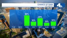
"Starting on Wednesday, that's when we have the first of two storms moving into the picture," said NBC4 forecaster Belen De Leon. "We don't really see the rain until Thursday morning, and then the potential sticks around throughout the day."
Widespread rain is possible Wednesday night, mostly in Ventura County, through Friday before another storm moves in during the holiday weekend.
"That one is going to be a colder one with less rain," De Leon said. "We're still several days away, and this storm system could take another route."
Here is the SoCal storm timeline
- Wednesday Night: Light rain in Ventura County
- Thursday Morning: Rain increases in LA County
- Thursday Afternoon Into Friday: Widespread rain
- Friday Afternoon: Rain decreases
- Saturday: Cold storm brings more rain
Snow levels will drop to from about 7,000 to 4,000 feet.
What to Make of California's December Weather
In October, the National Oceanic and Atmospheric Administration announced that a the Pacific Ocean was showing signs of a new La Nina, the flip side of the El Nino ocean-warming pattern, that tends to cause changes in weather worldwide.
Forecasters said much of California would have a 33% to 50% chance of below-normal precipitation, while only the state's far northern tier had equal chances of above- or below-normal precipitation.
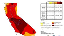
But the storm track has trended farther south than is usual during La Ninas. After a series of mid-December tempests, California's overall snow-water equivalent — a measurement of how much water is in the snowpack — jumped from 19% of normal to date on Dec. 10 to 76% of normal on Dec. 17, according to the latest U.S. Seasonal Drought Outlook.
While the current wet trend is positive, it is too early to know if it will last through January and February. The snowpack normally doesn't reach its maximum until April and last spring there was minimal runoff because much of the water was absorbed by the drought-parched landscape.
