Last year, California unveiled a four-tier and color-coded system based on coronavirus conditions in each of the state's 58 counties.
When it was first released, about 94 percent of California's population was under the most restrictive purple tier. Many would remain there for the better part of the next 12 months.
But by the end of March 2021, that number was down to three counties. And, by mid-April, there were no counties in the purple tier with most in the orange tier by the end of the month.
By the first week of May, Los Angeles County -- once the epicenter of the coronavirus pandemic in California -- moved into the yellow tier.
Get Southern California news, weather forecasts and entertainment stories to your inbox. Sign up for NBC LA newsletters.
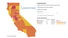
The map below shows where each county falls within the tiered system as of May 25. Updates are issued on Tuesdays to indicate eligibility for a tier.
Click here for the full interactive experience.
What can you do in each tier? Click here to find out.
Local
Get Los Angeles's latest local news on crime, entertainment, weather, schools, COVID, cost of living and more. Here's your go-to source for today's LA news.


California plans to move away from its tier system June 15, allowing most pandemic restrictions to end.
The state posts updates to its Blueprint for a Safer Economy system here. Find out what it means for you.
Counties must remain in a tier for at least three weeks before moving to a less restrictive tier. The next tier's criteria must be met for two consecutive weeks before a move to the less restrictive tier.