The window of opportunity is closing for Thanksgiving travelers.
A strong storm bringing three days of rain and snow is barreling south out of the Gulf of Alaska, threatening holiday plans for millions of Southern Californians who are driving to their destinations. An estimated 49.3 million people are driving from home for Thanksgiving, the second-highest volume recorded by the American Automobile Association since 2005.
Drivers should be ready for snow and ice on the 5 Freeway north of Los Angeles and other mountain passes with heavy rain elsewhere.
Here's what to expect for the rest of the week.
Wednesday
Local
Get Los Angeles's latest local news on crime, entertainment, weather, schools, COVID, cost of living and more. Here's your go-to source for today's LA news.


The system can be broken into two parts with the main cold front arriving Wednesday. Expect a brief period of heavy rain moving from west to east through the day.
Rain is expected in Los Angeles County by 6 a.m. The system will then move into the Inland Empire and reach Orange County by midday.
Here's the estimated timing of the cold front and the steadiest heavy rain.
- Ventura County, Santa Clarita Valley, San Fernando Valley: 4 a.m. to 10 a.m.
- Los Angeles County, Antelope Valley: 6 a.m. to Noon
- Inland Empire and Orange County: 9 a.m. to 2 p.m.
Showers are on the back end of the storm.
Snow levels will be starting around 5,000 feet and briefly climb above 6000 feet just ahead of the front. On the back side of the front, snow levels will quickly fall to below the Tejon Pass by the afternoon/evening hours.
"Three days worth of rain is going to cause some flood potential," said Mendiola. "It's also going to make driving difficult in those canyons and passes."
Most of the rainfall from this system will fall during a few hours on Wednesday, however right now it looks like we will sit below Flash Flood/Debris Flow thresholds of 0.50 inches per hour. It is still worth keeping an eye on Burn Scars. The primary flooding threat should be roadways and intersections, along with areas with poor drainage.
Thursday and Friday
The second part of the system arrives Thursday and Friday. It will mainly consist of showers on the back side of the cold front. Cold air will continue to move over the region, so snow levels will continue to fall all the way through Friday.
The cold air will also allow some isolated heavier showers to develop, with maybe a rumble of thunder. Thursday and Friday may not add much to rain totals. It really depends on where showers set up and how many showers are on the heavier side. The system looks to depart the region pretty quickly, so Friday may end up pretty dry.
A flash flood watch will be in effect from late Tuesday night through Thursday evening for multiple areas, including Orange County and parts of San Bernardino and Riverside counties. There could be heavy rain and small hail from Tuesday night until Friday — and even a few inches of snow near the Grapevine section of the 5 Freeway north of LA.
Snow Accumulations
- Above 3,000 feet (pass level): From 1 to 10 inches
- Above 5,000 feet (Wrightwood, Big Bear, Idyllwild): From 10 to 24 inches
- Above 7,000 feet: More than 2 feet
There will also likely be some flight delays due to the weather.
Anyone planning to visit the beach during the week of Thanksgiving should be aware of high surf and rip currents through Wednesday for LA, Orange and Ventura counties.
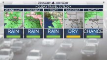
Weekend
Southern California will be dry later Friday and Saturday, but another chance of rain arrives Sunday.