
Canadian wildfire smoke has been choking the tri-state area for days now.
The prolonged problem is the result of a stalled weather pattern that happened at the wrong place and the wrong time for those in the Great Lakes, Northeast and Mid-Atlantic.
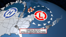
We’re under a weather pattern know as an "Omega Block" to meteorologists. Simply put, it’s a big ridge of high pressure over the center of North America with flanking low pressure areas over the East and West Coast.
Another weather system that has helped drive the great Canadian-American smokeout — a low-pressure system over Maine and Nova Scotia — "will probably be hanging around at least for the next few days," U.S. National Weather Service meteorologist Bryan Ramsey said.
Get Southern California news, weather forecasts and entertainment stories to your inbox. Sign up for NBC LA newsletters.
"Conditions are likely to remain unhealthy, at least until the wind direction changes or the fires get put out," Ramsey said. "Since the fires are raging — they’re really large — they’re probably going to continue for weeks. But it’s really just going be all about the wind shift."
The alignment of these high and low pressure systems causes the jet stream – the river of air running about 30,000 feet aloft — to become severely buckled. The shape of the flow resembles the Greek letter omega (Ω).
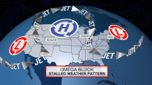
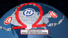
The buckled jet stream ends up creating the equivalent of an atmospheric traffic jam. It stops the migration of the high and low pressure systems, which leads to stagnant weather patterns.
In our case, the low pressure system along the East Coast is positioned perfectly to transport Quebec wildfire smoke directly down to the New York City area – day after day after day.
The smoke has been a problem since Tuesday, but you may have noticed it to be worse in the afternoon and evening compared to the early morning hours. It isn’t your imagination, it’s a real thing. But why does that occur?
Much of the wildfire smoke is carried in the wind flow aloft, several thousand feet up. During the day, as temperatures climb, the atmosphere becomes unstable. Pockets of warm, buoyant surface air begin to lift through the atmosphere – much like a hot air balloon rises.
To fill the void, colder air aloft mixes down to the surface and takes its place. A vertical circulation develops that is a very common phenomenon, but when there’s smoke lingering above, it gets mixes down to ground level, too. That’s a big reason why concentrations of smoke are worse in the afternoon and evening.
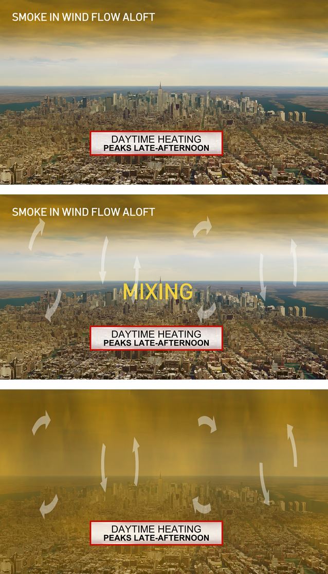
The atmosphere stabilizes and vertical mixing ceases as temperatures cool overnight, allowing the smoke to partly dissipate. By morning, the haze may still be there, but it’s less severe.
To end the smoky haze over the tri-state area, one of two things needs to happen. Either the fires get put out, or the wind patterns shift and blow the smoke away from us.
This week, it looks like a wind pattern shift is likely to occur first. The low pressure area over the East Coast will move out as we head through this weekend. This comes with a change in wind direction that we think will clear out a majority of the smoke.
As of Thursday afternoon, it looks like air quality this weekend will improve to moderate, which is safe.
Jennifer Peltz, Rob Gillies and Michael R. Sisak of the Associated Press contributed to this report.
