
What to Know
- Widespread rain and snow are in the forecast into Saturday.
- A blizzard warning is in effect for LA, Ventura and San Bernardino county mountains.
- Two to 5 feet of snow are possible by Saturday.
Steady rainfall and periods of intense downpours drenched widespread parts of Southern California overnight as a powerful winter storm moved through the region.
Rain is forecast to continue throughout much of Saturday as mountain communities face a rare blizzard warning. Rain was expected to diminish late Saturday and into Sunday.
Some neighborhoods are waking up to power outages, including in Studio City, Woodland Hills and other parts of the San Fernando Valley. Click here for the LADWP's outages map.
Get Southern California news, weather forecasts and entertainment stories to your inbox. Sign up for NBC LA newsletters.
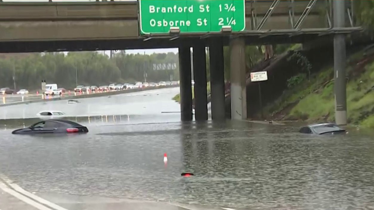
Flash flood warnings issued for parts of Ventura and Los Angeles counties expired overnight, when strong winds toppled trees, triggering power outages throughout the area. Flash flood watches remain in place.
"This storm is tapping into an atmospheric river and it's just enhancing our rainfall and snowfall amounts," said NBC4 forecaster Belen De Leon. "We have the possibility of these flooding conditions all the way through the night."
Hail fell on parts of Los Angeles, including the hills around the Hollywood Sign, Venice Beach. Pasadena, Santa Monica and Long Beach. Coastal and valley areas could get between 2 and 5 inches of rain during the storm by Saturday night, with 5 to 10 inches possible in the foothills.
The storm fueled by an atmospheric river over the Pacific unleashed a torrent of precipitation once it reached Southern California. The rivers of moisture in the sky have contributed to some of the wettest winters and most destructive storms in state history.
Temperatures will be in the 40s and 50s in most of the area, although they will drop into the 30s in the mountains and some valley areas, particularly at night, and into the 20s in the Antelope Valley. High winds will make it feel even colder.
Fallen trees were reported in areas like Santa Barbara and Valley Village where many cars were damaged. Over 9,000 of Southern California Edison customers in LA County were also affected by power outages during the storm.
The rainy weather forced closures and cancellations. The Major League Soccer season-opening match Saturday at the Rose Bowl between the LA Galaxy and LAFC was postponed until July 4. A BikeLA Cruise & Connect ride scheduled for Saturday through Griffith Park was also scrubbed.
Another storm is on track to arrive Tuesday into Wednesday.
"We've got another one coming," said NBC4 forecaster Shanna Mendiola. "It's going to add to the totals. We have that secondary storm moving in Monday, Tuesday and Wednesday."
Blizzard Warning for Southern California Mountains
A blizzard warning went into effect at 4 a.m. and will continue until 4 p.m. Saturday for LA and Ventura county mountains. Snow totals are expected to reach up to 5 feet at elevations above 4,000 feet by Saturday night.
Areas under the blizzard warning include, Mount Wilson, the Grapevine section of the 5 Freeway, Acton, Mount Pinos and Frazier Park. Travel is highly discouraged in Southern California's mountains.
"This is the second time we've seen a blizzard warning in over 30 years," said NBC4 forecaster Belen De Leon. "So we're going to see excessive snow in the mountains and gusts up to 75 mph, plus reduced visibility."
The blizzard warning does not include the Santa Monica Mountains.
The blizzard warning was extended Thursday to include the San Bernardino County mountains. Communities in the warning area area Wrightwood, Big Bear, Lake Arrowhead, Crestline and Running Springs.
The NWS San Diego office said the blizzard warning is the first issued by the office.
Two to 5 feet of snow are expected above 5,000 feet by Saturday as the storm continues to hammer the region. Some areas could get as much as 7 feet.
Snow accumulations of 6 to 12 inches are possible by Saturday night at elevations as low as 2,000 feet.
As of early Saturday, Bear Mountain Snow Summit received 45 inches of snow during the storm. Snow Valley received 32 to 36 inches, 26 inches were reported at Running Springs, and Lake Arrowhead received 23 inches.
A section of the 5 Freeway was closed north of Los Angeles due to snow and poor visibility.
What's a Blizzard Warning?
A blizzard warning generally indicates winter weather conditions that include snow, blowing snow, reduced visibility, strong sustained winds. It is a more severe weather warning that a winter storm warning.
Here's how the National Weather Service defines a blizzard warning.
The following conditions are occurring or expected within the next 12 to 18 hours.
- Snow and/or blowing snow reducing visibility to 1/4 mile or less for 3 hours or longer
and - Sustained winds of 35 mph or greater or frequent gusts to 35 mph or greater.
Note that there is no temperature requirement that must be met for blizzard conditions.
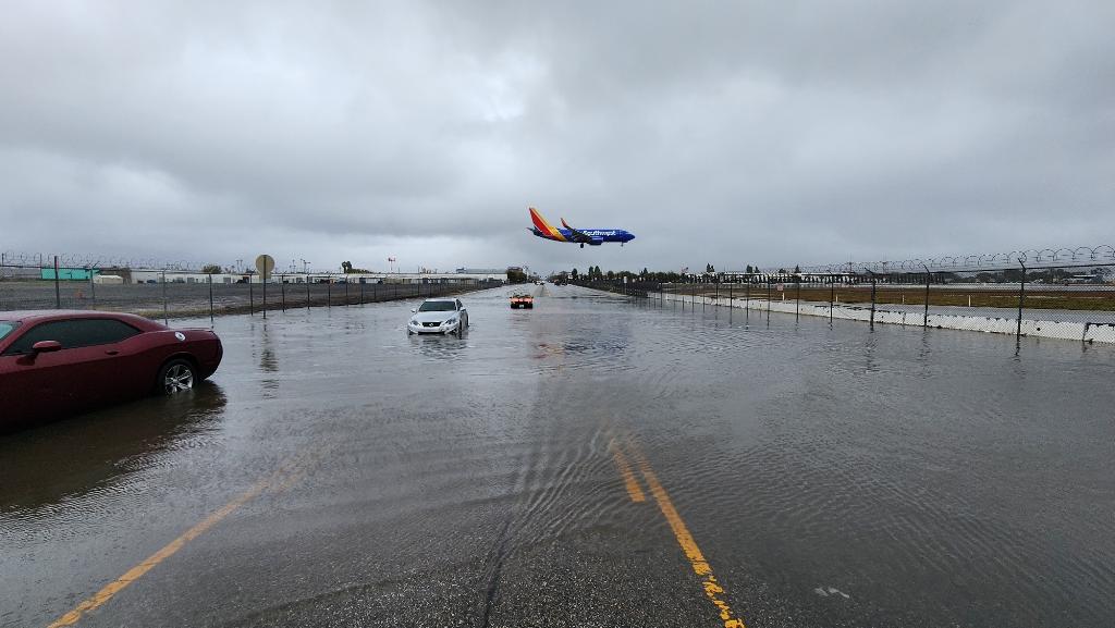
SoCal Weather Photos: Scenes From the Late-February Winter Storm
A less severe winter storm warning is issued when a combination of hazardous winter weather is occurring or imminent.
Significant and hazardous winter weather is defined by the National Weather Service as a combination of the following.
- Five inches or more of snow/sleet within a 12-hour period or 7 inches or more of snow/sleet within a 24-hour period
and/or - Enough ice accumulation to cause damage to trees or powerlines
and/or - A life threatening or damaging combination of snow and/or ice accumulation with wind.
California Drought Update
The most severe drought conditions that plagued California at the start of the water year in October were wiped out by January's storms, which also were fueled by atmospheric rivers.
In the most recent U.S. Drought Monitor report released Thursday, 33 percent of California was in severe drought, the weekly Monitor's third most severe category. At the start of the water year, 94 percent of the state was in severe drought.
Eighty-five percent of the state remains in moderate drought, the report's least severe category. That figure was at 99.76 percent at the start of the water year.
California has spent most of the last 15 years in drought conditions. The current three-year dry spell included one of the driest late winters on record.
The state's normal wet season runs from late fall to the end of winter, but dismal precipitation left about 95 percent of California in severe drought at the start of spring. By September, nearly all of California was in drought.
Much of California’s water comes from melting snow in the Sierra Nevada Mountains. In an ideal scenario, storms blanket the mountains with snow during winter, building up the natural reservoir. That snow then melts in late spring and early summer, replenishing the state's water system. Snowpack was far below normal in Spring 2022, but rebounded during January's storms.
