
What to Know
- The first storm arrived Thursday and delivered rain through Friday morning with the most significant rainfall overnight.
- A second storm is heading into Southern California this weekend.
- Temperatures will remain below normal into next week.
Light showers drenched parts of Southern California overnight as the first of two back-to-back storms passed through Southern California, leaving roads wet for the morning commute in Los Angeles.
The first storm arrived Thursday and delivered most of its rain overnight with drizzle and light showers possible through Friday morning. A second system will bring more rain, snow and cool temperatures this weekend.
"Our forecast is getting stormier and stormier," said NBC4 forecaster Belen De Leon.
Get top local stories in Southern California delivered to you every morning. >Sign up for NBC LA's News Headlines newsletter.
Here's what to expect from the two storms.
Storm No. 1: Scattered Showers Into Friday
Local
Get Los Angeles's latest local news on crime, entertainment, weather, schools, COVID, cost of living and more. Here's your go-to source for today's LA news.


The first storm entered Ventura and Los Angeles counties Thursday morning and made its was across the region throughout the day. Light rain was reported throughout the area with more drizzle and light showers possible during the afternoon.
"Unfortunately, this system is weakening as it moves through our area," De Leon said.
Rain amounts will be a half-inch to an inch with more in the mountains, where the snow level will be above 7,000 feet. Six to 12 inches of snow are possible.
Scattered showers are possible in the evening, likely after the height of the afternoon drive.
Highs Thursday were around 60 from the beaches to downtown Los Angeles and in the 50s in the San Fernando and San Gabriel valleys. Readings in the 50s were reported in Santa Clarita and the upper 40s to mid 50s in the Antelope Valley.
Average highs for this time of year are in the mid- to upper-60s. December is historically Southern California's third-wettest month, when rainfall averages 2.48 inches.
Showers will linger Friday morning before a break on Saturday.
Storm No. 2: Unsettled Weekend Weather
A second storm arrives Saturday with light rain through Sunday.
"That unsettled weather pattern is going to continue all the way into the weekend," De Leon said.
Showers are expected to taper off by early Sunday afternoon with clearing skies. No additional rain is in the forecast from Monday to Wednesday, but temperatures will stay below normal with light winds and sunshine.
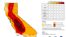
California Drought Update
California enters December will nearly all of the state in moderate drought, marking little change from this time last year. Nearly 85 percent of California is in severe drought, according to the most recent U.S. Drought Monitor report.
The weekly report, which includes four drought categories ranging from moderate to exceptional, showed more than 40 percent of California in extreme drought, the second most severe category. That includes a large swath of the state from the Ventura County coast, through the Central Valley and up to the Oregon-California border.
Part of the Central Valley is in exceptional drought.
California has spent most of the last 15 years in drought conditions. The current three-year dry spell included one of the driest late winters on record.
The state's normal wet season runs from late fall to the end of winter, but dismal precipitation left about 95 percent of California in severe drought at the start of spring with hot and dry summer months ahead.
Much of California’s water comes from melting snow in the Sierra Nevada Mountains. In an ideal scenario, storms blanket the mountains with snow during winter, building up the natural reservoir. That snow then melts in late spring and early summer, replenishing the state's water system.
Snowpack was far below in early 2022. California recorded its driest first three months of the year on record to start 2022. The dry stretch followed a promising December when storms drenched parts of the state and brought snow to the Sierra Nevada Mountains.