
What to Know
- Light showers will turn to heavier rainfall Monday afternoon and into the evening.
- A flood watch will be in effect from late Monday through Tuesday evening for most of Los Angeles County.
- Debris flows are possible in communities below recent Southern California burn scars.
Evacuation orders and warnings were issued Monday in Santa Barbara County as a strong winter storm with heavy rain moved south into the Los Angeles area.
Updated Article: When Will the Rain End?
The storm, fueled by a long plume of moisture over the Pacific Ocean, will deliver the heaviest rain Monday afternoon and into the evening. The wet weather follows last week's powerful winter storm that flooded some SoCal streets and freeways.
Get Southern California news, weather forecasts and entertainment stories to your inbox. Sign up for NBC LA newsletters.
"We're expecting more rain than the last one we saw," said NBC4 forecaster Belen De Leon. "That was a pretty strong storm. This one's expected to be stronger.
"We're anticipating the strongest rain to arrive for the afternoon and evening commute."
A flood watch will be in effect from late Monday through Tuesday evening for the Los Angeles County coast, mountains, downtown Los Angeles, the San Fernando, Santa Clarita, San Gabriel and Antelope valleys and inland areas including Hollywood, Compton, Long Beach, Pomona, Downey, Norwalk, East Los Angeles, Culver City, Lakewood and Beverly Hills
The flood watch also impacts Orange County's coastal areas, inland areas, including Santa Ana, Anaheim, Garden Grove, Irvine, Orange, Fullerton and Mission Viejo, and the Santa Ana Mountains and foothills.
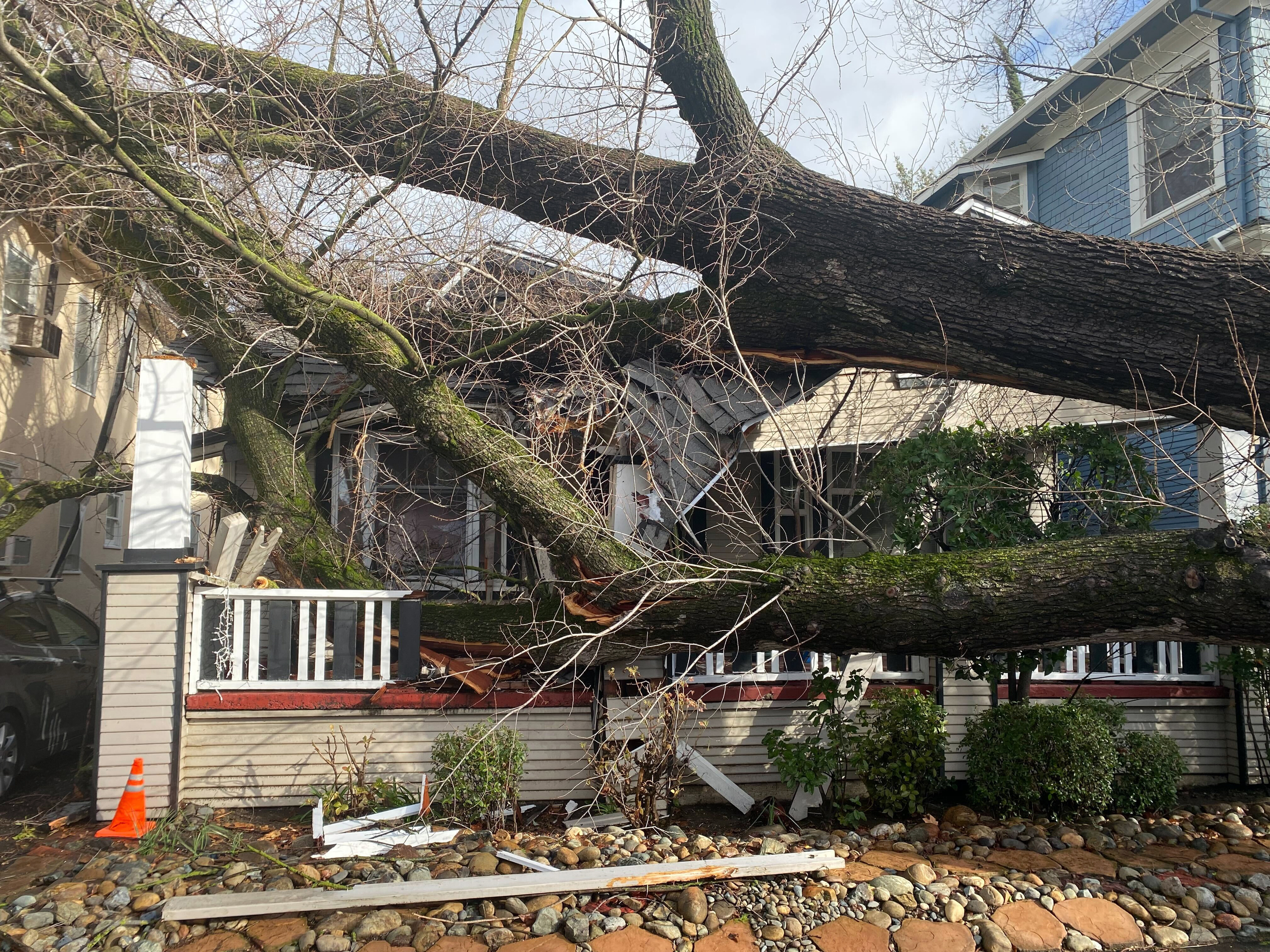
The storm was on track to deliver 2-4 inches of rain for the coast and valleys, and up to 10 inches in the mountains. Small stream flooding is possible and communities below recent burns are preparing for possible debris flows.
Strong wind gusts of up to 70 mph were in the forecast for Los Angeles County mountains. The Antelope Valley was expected to see gusts up to 60 mph Monday.
High surf was expected through Tuesday, with large waves on west-facing beaches.
The snow level could drop to 6,000 feet Tuesday.
Temperatures will stay cool with highs in the lower 60s. Overnight lows will mostly be in the 40s and lower 50s, but will drop into the 30s in the mountains and high desert.
Partly sunny skies will return Wednesday and Thursday, but more rain is possible next weekend, possibly as early as Friday night.
Santa Barbara County Evacuations
In Santa Barbara County, an evacuation order was issued for the Thomas Fire burn area due to the possibility of flooding and debris flows.
More than 5 inches of rain were reported in the Montecito area, site of a deadly 2018 debris flow, as of 3 a.m. Monday. The evacuation order was extended to all of Montecito, Toro Canyon, Sycamore Canyon, and Padaro Lane.
Evacuation warnings were issued for the Alisal and Cave fire burn areas in Santa Barbara County. The warnings could become evacuation warnings later Monday as the storm continues to hammer slide-prone areas.
The northbound 101 Freeway was closed at Mariposa Reina due to debris flow in the area. State Route 154 was closed in both directions at State Route 246 and State Route 192 due to rock slides.
It was also closed at the 33 through Santa Claus Lane. Officials said to expect flooding along sections of the northbound 101 Freeway throughout Summerland and Montecito. The Northbound 101 was also closed at Gaviota Highway.
San Ysidro Creek was seen flooding on Jameson Lane around 3:30 p.m.
Five years ago, Montecito in Santa Barbara was the site of devastating flooding and mudslide that left 13 dead in January 2018.
Ellen DeGeneres tweeted a video from Montecito showing the raging floodwaters passing behind her.
"Montecito is under mandatory evacuation. We are on higher ground so they asked us to shelter in place. Please stay safe everyone," she captioned the video.
DeGeneres went on in the video to highlight the five-year anniversary of the 13 who lost their lives, and the others who lost their homes.
"We need to be nicer to mother nature, because mother nature is not happy with us," she said.
UC Santa Barbara also canceled classes Monday afternoon due to the storm.
Flash Flood Warnings
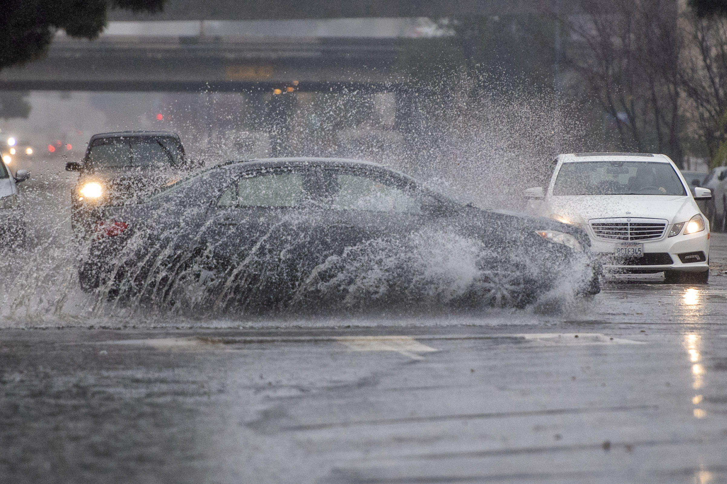
Flash Flood Warnings were issued in LA and Ventura counties Monday afternoon, as images of flooding in the northern region of California came pouring in.
Flash flood warnings were in effect for the northwestern area of LA County, and for the city of Oxnard in Ventura County until 9 p.m. PST.
Flooding was already being seen in the region, as moderate and heavy rain began to shower over SoCal.
Flooding was reported in Fillmore, Ojai, Santa Clarita, Santa Paula, Lockwood Valley, Lake Hughes, and Elizabeth Lake.
Authorities were also keeping an eye on burn scars that may become affected, like Lake, Route, Emigrant, Hungry, Tumbleweed, and North.
Parade of Atmospheric Rivers
Atmospheric rivers, long plumes of moisture stretching out into the Pacific capable of dropping significant amounts of rain and snow, are fueling recent deadly storms that caused flooding in Northern California. The rivers in the sky are behind some of the state's most devastating storms.
The wet weather comes after days of rain from Pacific storms that last week knocked out power to thousands, flooded streets and slammed the coastline. The first of the heavier storms this week prompted the weather service to issue a flood watch for a large swath of Northern and Central California with 6 to 12 inches of rain expected through Wednesday in the already saturated Sacramento-area foothills.
More than 60,000 customers were still without electricity Sunday evening in Sacramento, after powerful wind gusts knocked down trees into power lines, according to the Sacramento Municipal Utility District.
Photos: Scenes From Southern California's January Storm
Gov. Gavin Newsom said 12 people has been killed during the storms in the past 10 days. Hee warned that this week's storms could be even more dangerous and urged people to stay home.
"Just be cautious over the course of the next week, particularly the next day or two or so," Newsom said during a briefing with California officials outlining the state's storm preparations.
Evacuation warnings were in place for about 13,000 residents of a flood-prone area of Sonoma County north of San Francisco. The Russian River was expected to overspill its banks in the coming days.
Sacramento County ordered evacuations for people living around Wilton, a town of about 6,000 roughly 20 miles southeast of downtown Sacramento. The rural area along the Cosumnes River saw flooding in an earlier storm.
The state Department of Transportation warned drivers to stay off mountain roads. A stretch of U.S. 395 in Mono County, along the Eastern Sierra, was closed due to heavy snow, ice and whiteout conditions.
California Drought
California's drought conditions improved after early winter storms brought widespread rain and much-needed snow in the Sierra Nevada Mountains.
Nearly 98 percent of the state remains in at least one of the four drought categories in the weekly U.S. Drought Monitor report released Thursday morning, but no part of California is in the most severe category. Last week, more than 7 percent of the state was in exceptional drought.
The most recent report includes data available through Dec. 2, meaning results from last week's powerful storm is not included. The storm arrived Wednesday and intensified overnight into Thursday.
California has spent most of the last 15 years in drought conditions. The current three-year dry spell included one of the driest late winters on record.
The state's normal wet season runs from late fall to the end of winter, but dismal precipitation left about 95 percent of California in severe drought at the start of spring. By September, nearly all of California was in drought.
Much of California’s water comes from melting snow in the Sierra Nevada Mountains. In an ideal scenario, storms blanket the mountains with snow during winter, building up the natural reservoir. That snow then melts in late spring and early summer, replenishing the state's water system
The snowpack covering California's mountains is off to one of its best starts in 40 years, raising hopes that the drought-stricken state could soon see relief in the spring when the snow melts and begins to refill parched reservoirs.
Statewide, snowpack is at 174% of the historical average for this year, the third-best measurement in the past 40 years. Even more snow is expected later this week and over the weekend, giving officials hope for a wet winter the state so desperately needs.
