What to Know
- A La Niña pattern is strengthening over the Pacific as we head toward winter, which could have significant impacts on SoCal's weather.
- Since 1950, there have been 22 different La Niña. Most have been on the drier side with below average rain.
- But even during dry years, SoCal has seen some powerful storms that unleashed natural disasters.
Winter is usually the wettest season in Southern California, but due to a strengthening La Niña pattern in the Pacific, this winter is looking warmer and drier than normal.
La Niña and El Niño are opposite phases of what's known as the El Nino-Southern Oscillation cycle (ENSO). La Niña is the cold phase and develops due to below average temperatures in the equatorial Pacific. This affects weather patterns across the globe. In the U.S., high pressure in the Eastern Pacific steers storms across the northern part of the country instead of the south.

Eric Boldt from the National Weather Service in Oxnard says we'll still see rain, except we may end up short of what we typically would want to have for a normal season.
"We still have to be prepared for those strong individual storms that could still cause problems with flash flooding and debris flows, especially near the recent burn scars,” he said.
Since 1950, there have been 22 different La Niña. Most have been on the drier side with below average rain, but there have been significant storms during dry years. The most recent La Niña winter in 2017-2018 was below average, but heavy rain arrived in January after the Thomas Fire.
Just because the seasonal outlook might mean that we'll have a better chance for below normal precipitation, it does only take one storm to create a lot of problems.
Mark Jackson, meteorologist at the NWS in Oxnard
"On January 19th, that was the Montecito debris flow. That was a heavy rain event with very high rainfall rates in a short period of time," said Mark Jackson, meteorologist at the NWS in Oxnard. "So again, just because the seasonal outlook might mean that we'll have a better chance for below normal precipitation, it does only take one storm to create a lot of problems."
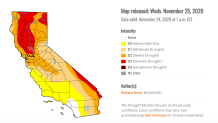
The most recent drought monitor shows 96% of California is under a drought with abnormally dry conditions for Southern California. A dry winter could extend the already record-breaking fire season.
David Gomberg of the NWS says that because this year we've been exceptionally dry, and we've had record setting heat waves throughout the summer our vegetation is in a very critical stage. "As we move into December and into January, we can still be entering fire season at that point."