
Keep the umbrella around into the weekend.
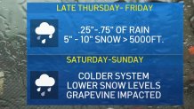
The second of this week's two storms will bring periods of rain and snow through at least part of Sunday.
“We’re settling into this very unsettled weather pattern,” said NBC4 forecaster Belen De Leon. “Get the umbrella out, and just leave it out all through Saturday.”
Get Southern California news, weather forecasts and entertainment stories to your inbox. Sign up for NBC LA newsletters.
The second system arrived Saturday and continues into Sunday. Winter storm watches and warnings will be in effect through Sunday morning in the mountains.
“It is going to be a tough go on those mountain roads,” said De Leon.
Up to five inches of snow fell over 48 hours through Friday evening at Mount Pinos in Southern California's Los Padres National Forest. An inch was reported at the Mountain High ski resort near Los Angeles.
Up to 18 inches of snow could fall above 7,000 feet by early Sunday.
The snow level might drop as low as 3,000 feet. Temperatures will fall a few more degrees, keeping most of the region in the mid to upper 50s.
A winter weather advisory will be in effect until 10 a.m. Sunday in the Los Angeles County Mountains, excluding the Santa Monica Range.
About 6 to 12 inches of snow was expected in the Ventura and Los Angeles County Mountains -- with the heaviest accumulations in the eastern San Gabriel Mountains.
Winds gusting to 50 mph were expected in that area, especially tonight and Saturday night.
Expect slippery road conditions along the 5 Freeway over the Grapevine, Highway 33 through the Grapevine and Highway 2 through the San Gabriel Mountains.
Temperatures should begin to rebound on Sunday with clear skies. Warmer weather is expected to return by Monday.
The week's first system moved down the coast Thursday brought light rain overnight and snow in the mountains.
Van Nuys recorded .37 inches of rainfall as of 4 a.m., according to the National Weather Service. Northridge recorded .18 inches and Hansen Dam recorded .16 inches. Newhall recorded .11 inches and the Santa Fe Dam in the San Gabriel Valley recorded .13 inches of rain. Rainfall totals Friday are expected to be low, with most areas receiving a quarter- to three-quarters of an inch, although the
San Gabriel Mountains could get slightly more.
By Friday morning, the heaviest rain ended after a night when an estimated 75 lightning strikes reported since midnight in Southern California.
The cold systems provide a contrast from Wednesday, when record high temperatures were reported in parts of Los Angeles County. In Woodland Hills, temperatures reached a high of 87, matching a record set in 1946. In Burbank, at Bob Hope Airport, temperatures reached 85, matching a record set in 1972.
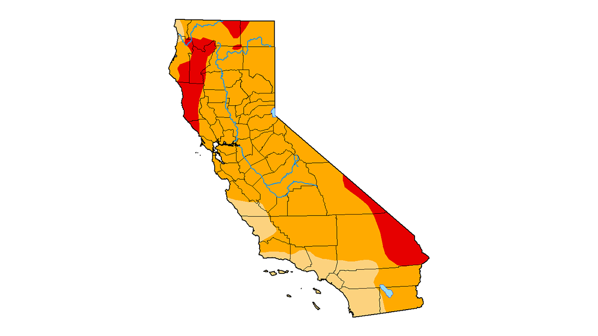
All of California remains in some level of drought following predominantly dry months in January and February. The dismal stretch of dry weather followed a late December that saw a conveyor belt of storms soak the region, easing the worst drought conditions throughout California.
