


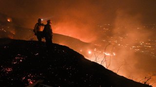
TOPSHOT – Firefighters look out over a burning hillside as they fight the Blue Ridge Fire in Yorba Linda, California, October 26, 2020. – Some 60,000 people fled their homes near Los Angeles on October 26 as a fast-spreading wildfire raged across more than 7,200 acres (3,000 hectares), blocking key roadways and critically injuring two firefighters. (Photo by ROBYN BECK/AFP via Getty Images)
The map below shows where California's wildfires are burning (updated daily). Use the layover tool to the right to toggle between displays, including fire perimeters.

- The red fire symbols classify the fire by acres. The symbol increases in size as the fire increases in coverage.
- The polygons show current perimeters.
- The map legend also shows Hazardous Wildfire Conditions: Red Flag Warning and Fire Weather Watch.
Get Southern California news, weather forecasts and entertainment stories to your inbox. Sign up for NBC LA newsletters.

