Study Suggests Ridgecrest Quakes Changed the Odds of a Big San Andreas Earthquake
The back-to-back strong earthquakes in 2019 might have increased the chances of a quake along the San Andreas Fault with a magnitude of 7.5 or greater in the next 12 months, the study says.
•
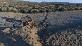
ROBYN BECK/AFP/Getty Images
Seismologist Dr. Steven Wesnousky explains the surface ruptures and offsets seen on the desert areas impacted by yesterday’s magnitude 7.1 earthquake, near the epicenter along California State Route 178 between Ridgecrest and Trona California on June 6, 2019. (Photo by Robyn Beck / AFP) (Photo credit should read ROBYN BECK/AFP/Getty Images)
The Ridgecrest earthquakes in 2019 may have upped the chances of a quake along the San Andreas fault with magnitude 7.5 or greater in the next 12 months, according to a study published Tuesday in the Bulletin of the Seismological Society of America.
The Los Angeles Times reported on the findings that there is a 2.3% chance of a large earthquake on the Garlock fault, which runs along the north edge of the Mojave Desert, in the next year. That increases the likelihood of a big shake-up on the larger San Andreas fault to 1.15%.
AFP/Getty Images
Resident Steve Ault, wearing a shirt that reads "Ridgecrest Has Its Faults," sits on a surface rupture caused by yesterday's magnitude 7.1 earthquake, near the epicenter along California State Route 178 between Ridgecrest and Trona, California. Local residents and out of town visitors flocked to the spot to see the earthquake's geologic effects on the earth's surface.
USGS
USGS Seismologists Alan Yong and Elizabeth Cohcran work near the main rupture between Trona and Ridgecrest, California.
Getty Images
Ridgecrest residents take photos at a recent fault rupture following two large earthquakes in the area on July 7, 2019 near Ridgecrest, California. A 6.4 magnitude 'foreshock' on July 4 was followed by a 7.1 magnitude earthquake the next day. The 7.1 magnitude temblor was the largest in Southern California in twenty years. (Photo by Mario Tama/Getty Images)
NBC 5 News
Railroad tracks were offset right-laterally by about 3 fee southeast of Highway 178 during the Friday July 5, 2019 magnitude-7.1 earthquake near Ridgecrest, California.
ROBYN BECK/AFP/Getty Images
Seismologist Dr. Steven Wesnousky is pictured at the surface ruptures and offsets seen on the desert areas impacted by the July 5, 2019, magnitude 7.1 earthquake, near the epicenter along California State Route 178 between Ridgecrest and Trona, California, on June 6, 2019.
AFP/Getty Images
People drive over a surface rupture on the desert areas impacted by the magnitude 7.1 earthquake, near the epicenter along California State Route 178 between Ridgecrest and Trona, California.
AFP/Getty Images
Surface ruptures and offsets caused by a magnitude 7.1 earthquake are seen as the sun sets along State Route 178 between Ridgecrest and Trona, California.
EFE / Archivo
Surface ruptures and offsets caused by a magnitude 7.1 earthquake are seen as the sun sets along State Route 178 between Ridgecrest and Trona, California. Local residents and out of town visitors flocked to the spot to see the earthquake's geologic effects on the earth's surface.
AFP/Getty Images
Resident Steve Latham surveys the effects of a magnitude 7.1 earthquake, along California State Route 178 between Ridgecrest and Trona, California.
AFP/Getty Images
Resident Steve Latham uses his leg to measure the amount of offset in the desert floor caused by a magnitude 7.1 earthquake, along California State Route 178 between Ridgecrest and Trona, California. Local residents and out of town visitors flocked to the spot to see the earthquake's geologic effects on the earth's surface.
Getty Images
An onlooker stands near newly ruptured ground after a 7.1 magnitude earthquake struck in the area near Ridgecrest, California. The earthquake, which occurred July 5, was the second large earthquake to hit the area in two days and the largest in Southern California in 20 years.
WAVE
This image shows right-lateral slip across fractures on a hillside with shattered ground along the surface fault rupture near Ridgecrest, California.
USGS
USGS scientists and partners review prepare to document surface faulting.
Those low probabilities may seem hardly worth worrying about given more pressing concerns of the COVID-19 pandemic, however, the numbers translate into a near tripling of the odds of a large quake on the San Andreas, one of the study's co-authors told The Times.
Ross Stein, an earthquake scientist emeritus of the U.S. Geological Survey and adjunct professor of geophysics at Stanford University told the newspaper that if the Garlock fault ruptures, the probability of a big earthquake along the San Andreas fault could be even odds.
USGS
These photos show the aftermath of the 1971 San Fernando Earthquake.
USGS
A damaged section of freeway overpass is pictured following the 1971 San Fernando Earthquake.
USGS
An ambulance was crushed by the collapse of the Olive View Medical Center in Sylmar during the 1971 San Fernado Earthquake.
USGS
A damaged steel-reinforced support for the 5 and 14 freeway overpass was damaged in the 1971 San Fernando Earthquake.
USGS
This image shows a damaged section of the Van Norman Reservoir pipeline. Notice the popped bolts at the bottom of the frame.
USGS
This aerial view shows a collapsed section of the lower Van Norman Dam after the 1971 San Fernando Earthquake.
USGS
An aerial view of displaced railroad tracks in Sylmar after the 1971 San Fernando Earthquake.
USGS
A view inside Olive View Medical Center after the 1971 San Fernando Earthquake.
USGS
This photo shows damage at Olive View Medical Center following the 1971 San Fernando Earthquake.
USGS
Electrical equipment was damaged in Sylmar in the 1971 San Fernando Earthquake. Power to more than 600,000 customers was disrupted.
USGS
A view inside the Los Angeles County Juvenile Facility in Sylmar, where shaking caused a crack in the girls dormitory.
USGS
The 1971 San Fernando Earthquake damaged a pipe on the Maclay Reservoir outlet line in Sylmar.
USGS
USGS
This view is looking northeast at the Sylmar Converter Station above the Van Norman Dam after the 1971 San Fernando Earthquake.
USGS
A view outside the Foothill Nursing Home in Sylmar following the 1971 San Fernando Earthquake.
USGS
A driveway slab was lifted in the Sylmar area during the 1971 San Fernando Earthquake.
E. Leyendecker, USGS
A view of the Van Norman Dam after its partial collapse in the 1971 Sylmar Earthquake.
USGS
Damaged pavement and curbing is pictured in Sylmar following the 1971 San Fernando Earthquake.
USGS
This aerial photo shows a housing development northeast of Shinsaw Avenue and Hubbard Street in the Sylmar area. Many homes in the area were damaged in the 1971 San Fernando Earthquake.
USGS
A view of the northern Sylmar area showing the 210 Freeway under construction. Olive View Hospital is in the upper part of this photo.
USGS
This map illustrates widespread shaking from the 1971 San Fernando earthquake in Southern California.
“Now, you can think of the Ridgecrest earthquake as being so far from Greater Los Angeles... that it is nearly harmless,'' Stein told The Times. “But the problem is that ... the Ridgecrest earthquake brought the Garlock fault closer to rupture. If that fault ruptures -- and it gets within about 25 miles of the San Andreas -- then there's a high likelihood, maybe a 50/50 shot, that it would immediately rupture on the San Andreas.”
A hypothetical magnitude 7.8 quake on the San Andreas could cause more than 1,800 deaths, injure 5,000, displace 500,000 to 1 million people from their homes and cripple the region economically for a generation, The Times reported. A quake of that magnitude would produce 45 times more energy than the 1994 magnitude 6.7 Northridge quake.
Seismologist Dr. Lucy Jones, who was not involved in the study, said its conclusions are not confirmed.
“It's really interesting science, and I like the way they've been able to increase the complexity of how they do their modeling,'' Lucy Jones told the newspaper. “That's a real advance. But it's not yet proven.”
However, even Jones said California officials should be prepared and on the lookout for action on the Garlock fault.
The series of earthquakes in Ridgecrest in 2019 culminated in the largest seismic event in the state since the 1999 7.1 magnitude Hector Mine quake, according to an abstract of the report.
The Ridgecrest activity “produced significant stress perturbations on nearby fault networks, especially along the Garlock fault segment immediately southwest of the 2019 Ridgecrest rupture,'' according to that brief summary.
The question is whether that stress may have begun a chain of events that could result in a widespread devastation along the San Andreas fault not seen since 1857, The Times noted.
A year ago, the U.S. Geological Survey -- the nation's primary earthquake science agency -- calculated that there was an extremely remote chance the San Andreas could be triggered by the Ridgecrest quakes, the newspaper reported.