Magnitude-3.2 Earthquake North of LA Shakes Parts of SoCal
The Valentine's Day quake was centered about four miles west of Stevenson Ranch.
•
USGS
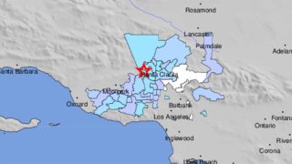
A magnitude-32 earthquake was reported Feb. 14, 2022 north of Los Angeles.
A magnitude-3.2 earthquake was reported Monday morning north of Los Angeles.
The quake was centered about four miles west of Stevenson Ranch. Shaking was reported in the Santa Clarita and Valencia area, the San Gabriel and San Fernando valleys and other parts of Southern California.
USGS
These photos show the aftermath of the 1971 San Fernando Earthquake.
USGS
A damaged section of freeway overpass is pictured following the 1971 San Fernando Earthquake.
USGS
An ambulance was crushed by the collapse of the Olive View Medical Center in Sylmar during the 1971 San Fernado Earthquake.
USGS
A damaged steel-reinforced support for the 5 and 14 freeway overpass was damaged in the 1971 San Fernando Earthquake.
USGS
This image shows a damaged section of the Van Norman Reservoir pipeline. Notice the popped bolts at the bottom of the frame.
USGS
This aerial view shows a collapsed section of the lower Van Norman Dam after the 1971 San Fernando Earthquake.
USGS
An aerial view of displaced railroad tracks in Sylmar after the 1971 San Fernando Earthquake.
USGS
A view inside Olive View Medical Center after the 1971 San Fernando Earthquake.
USGS
This photo shows damage at Olive View Medical Center following the 1971 San Fernando Earthquake.
USGS
Electrical equipment was damaged in Sylmar in the 1971 San Fernando Earthquake. Power to more than 600,000 customers was disrupted.
USGS
A view inside the Los Angeles County Juvenile Facility in Sylmar, where shaking caused a crack in the girls dormitory.
USGS
The 1971 San Fernando Earthquake damaged a pipe on the Maclay Reservoir outlet line in Sylmar.
USGS
USGS
This view is looking northeast at the Sylmar Converter Station above the Van Norman Dam after the 1971 San Fernando Earthquake.
USGS
A view outside the Foothill Nursing Home in Sylmar following the 1971 San Fernando Earthquake.
USGS
A driveway slab was lifted in the Sylmar area during the 1971 San Fernando Earthquake.
E. Leyendecker, USGS
A view of the Van Norman Dam after its partial collapse in the 1971 Sylmar Earthquake.
USGS
Damaged pavement and curbing is pictured in Sylmar following the 1971 San Fernando Earthquake.
USGS
This aerial photo shows a housing development northeast of Shinsaw Avenue and Hubbard Street in the Sylmar area. Many homes in the area were damaged in the 1971 San Fernando Earthquake.
USGS
A view of the northern Sylmar area showing the 210 Freeway under construction. Olive View Hospital is in the upper part of this photo.
USGS
This map illustrates widespread shaking from the 1971 San Fernando earthquake in Southern California.