


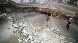
FILE – In this Jan. 17, 1994 file photo, Interstate 10, the Santa Monica Freeway, split and collapsed over La Cienega Boulevard following the Northridge quake in the predawn hours in Los Angeles. Twenty-five years ago this week, a violent, pre-dawn earthquake shook Los Angeles from its sleep, and sunrise revealed widespread devastation, with dozens killed and $25 billion in damage. (AP Photo/Eric Draper, File)
Early morning shaking from the 1994 Northridge Earthquake marked a terrifying moment in a tragedy that changed Los Angeles and the way Southern Californians think about earthquakes.
Jolting many residents awake at 4:31 a.m., shaking was felt across a widespread area before dawn. Daylight and the search for victims in the hours that followed revealed devastation that had not been seen from an earthquake in Southern California since the 1971 San Fernando Earthquake.
Below, a look back at notable Southern California earthquakes since the Northridge Earthquake in January 1994.
Northridge Earthquake
Get Southern California news, weather forecasts and entertainment stories to your inbox. Sign up for NBC LA newsletters.
It’s not the largest magnitude earthquake on this list, but it is by far the most devastating. The Northridge Earthquake centered in the west San Fernando Valley began rattling Los Angeles on Jan. 17, 1994 at 4:31 a.m., a moment seared into the memories of residents who were awakened by the terrifying shaking. More than 60 people died. More than 9,000 people were injured and 20,000 were displaced in a natural disaster that caused an estimated $20 billion in damage. The destruction included collapsed buildings and freeway overpasses, snapped water and gas lines, rampant fires and landslides.
Ridgecrest Earthquake Sequence
Thursday’s magnitude-6.4 quake was in the same area that was struck by a magnitude-5.4 quake in 1995. That Aug. 17, 1995 earthquake, centered north of Ridgecrest, was followed by more than 2.500 aftershocks during the following five weeks. On Sept. 20 that same year, a second large earthquake struck the region. At magnitude-5.8, it was likely on the same fault system as the earlier quake. More than 1,900 aftershocks followed the September earthquake.
Local
Get Los Angeles's latest local news on crime, entertainment, weather, schools, COVID, cost of living and more. Here's your go-to source for today's LA news.


Hector Mine Earthquake
In October 1999, one of the largest earthquakes recorded in Southern California was centered in the desert east of LA. The magnitude-7.1 Hector Mine quake produced shaking throughout SoCal and in parts of Arizona to Nevada from its epicenter in the Mojave Desert. It was in such a remote location that it was named after an open quarry pit and caused little damage, aside from a surface rupture in the Twentynine Palms Marine Base.
Laguna Salada Earthquake
On the morning of Feb. 22, 2002, a magnitude-5.7 earthquake shook a widespread part of the U.S.-Mexico border region and as far north as Orange County. Thirteen significant aftershocks, measuring magnitude 3 or greater followed. The same fault likely produced a magnitude-7.0 quake in 1890
Northern Baja Earthquake
In late December 2009, the U.S.-Mexico border was again the site of a quake that rattled a large part of Southern California. The magnitude-5.8 Northern Baja quake was located about 22 miles southeast of Calexico, California. It's likely the quake involved a zone of faults that run parallel to, but are separate from, the infamous San Andreas Fault.
Sierra El Mayor
Rumbling that originated from northern Baja California surged throughout Southern California and into parts of Arizona and Nevada. The magnitude-7.2 quake generated moderate shaking in SoCal.
Independence Day Quake
Just as Southern Californians were settling in for a day off and celebratory fireworks, the shaking set in -- and kept going and going. It was a magnitude-6.4 earthquake centered in the Searles Valley area about 150 miles northeast of Los Angeles. The quake caused damage in the immediate area, but only rattled a few nerves in the LA area.
July 5, 2019 Earthquake
What we thought to be the main event turned out to be a foreshock. A day after the magnitude-6.4 Searles Valley quake, a magnitude-7.1 earthquake generated a strong swaying motion throughout Los Angeles and the surrounding area. Click here for updates.
Aug. 20, 2023 Hurriquake
Remembered not so much for it's strength or the damage it caused, the 2023 'Hurriquake' was notable for when it occurred. Mother Nature dealt Southern California a one-two punch Aug. 20, 2023 when an earthquake in Ventura County triggered widespread shaking on the same day as the region was drenched by its first tropical storm in decades. The magnitude-5.1 earthquake at 2:41 p.m. startled Southern Californians who were already braced for the remnant of Hurricane Hilary

