Drought Conditions Improve in Northern, Central California
Reservoir and snowpack levels have improved as California reaches the end of its rain season
By Jonathan Lloyd ••
Conditions are improving in some parts of the state as California nears the end of its water year. Crystal Egger has a drought update for Thursday March 17, 2016.
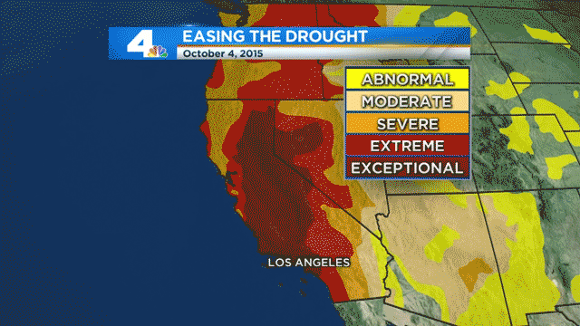
Drought conditions improved this week for some parts of California as a steady stream of storms have nearly filled northern water reservoirs and improved the critical Sierra snowpack, according to this week's Drought Monitor report.
Improvements were reported in several drought condition categories, ranging from moderate to exceptional, as California nears the end of its rain season, which began in October. About 74 percent of the state is under severe drought, a 10-percentage point improvement over the previous week's report.
Getty
These composite images show California's dramatic change from 2014 to 2017, when winter storms brought historic rainfall to drought-stricken areas.
California Department of Water Resources
An aerial view of Brown's Ravine Marina at Folsom Lake in El Dorado County, California on Nov. 1, 2017. Kelly M. Grow/ California Department of Water Resources
California Department of Water Resources
An aerial view of Brown's Ravine Marina located on the south shore of Folsom Lake in El Dorado County, California. The lake was at 78 percent of total capacity or 109 percent of historical capacity. Photo taken on April 21, 2017. Kelly M. Grow/ California Department of WaternResources
California Department of Water Resources
An aerial view of Folsom Lake at 78 percent of total capacity or 109 percent of historical capacity. Photo taken on April 21, 2017. Kelly M. Grow/ California Department of WaternResources
California Department of Water Resources
A view from the Lake Oroville flood control spillway looking east over the lake waters at an elevation 810.80 feet. Photo taken July 10, 2017. Dale Kolke / California Department of Water Resources, FOR EDITORIAL USE ONLY
Getty Images
In this composite image a comparison has been made between a view of California during severe drought in 2014 (top) and during the week that the majority of the state's drought emergency is due to be lifted (bottom).
Getty Images
In this composite image a comparison has been made between a view of California during severe drought in 2014 (top) and during the week that the majority of the state's drought emergency is due to be lifted (bottom).
Getty Images
In this composite image a comparison has been made between a view of California during severe drought in 2014 (top) and during the week that the majority of the state's drought emergency is due to be lifted (bottom).
Getty Images
In this composite image a comparison has been made between a view of California during severe drought in 2014 (top) and during the week that the majority of the state's drought emergency is due to be lifted (bottom).
Getty Images
In this composite image a comparison has been made between a view of California during severe drought in 2014 (top) and during the week that the majority of the state's drought emergency is due to be lifted (bottom).
Getty Images
In this composite image a comparison has been made between a view of California during severe drought in 2014 (top) and during the week that the majority of the state's drought emergency is due to be lifted (bottom).
AP
Frank Gehrke, chief of the California Cooperative Snow Surveys Program for the Department of Water Resources, crosses a snow covered meadow after conducting the second manual snow survey of the season at at Phillips Station Thursday, Feb. 2, 2017, near Echo Summit, Calif. (AP Photo/Rich Pedroncelli)
AP
Fog and mist shroud the Sierra Nevada, Thursday, Feb. 2, 2017, near Echo Summit, Calif. The California Department of Water Resources held the second manual snow survey Thursday at nearby Phillips station. The results -- way above average snowpack with a statewide reading of 173 percent of normal.
AP
Frank Gehrke, right, chief of the California Cooperative Snow Surveys Program for the Department of Water Resources, checks the depth of the snowpack as he conducts the second manual snow survey of the season at Phillips Station, Thursday, Feb. 2, 2017, near Echo Summit, Calif. (AP Photo/Rich Pedroncelli)
AP
Snow covered mountain tops rise behind downtown Los Angeles from Kenneth Hahn State Recreation Area in Los Angeles, Wednesday, Jan. 25, 2017. After years of drought and barren slopes, skiers and boarders have a bonanza of snow at resorts from the Sierra Nevada to the mountain ranges of Southern California following a barrage of storms. (AP Photo/Richard Vogel)
Kelly M. Grow/California Department of Water Resources
Lake Oroville's concrete launch ramp at Bidwell Canyon on Jan. 25, 2017. Below, the Bidwell Canyon launch ramp at Lake Oroville on Jan. 11, 2016.
AP
Mountain tops East of Los Angeles are covered with snow seen from Los Angeles, Tuesday, Jan. 24, 2017. After years of drought and barren slopes, skiers and boarders have a bonanza of snow at resorts from the Sierra Nevada to the mountain ranges of Southern California following a barrage of storms. East of Los Angeles, the Bear Mountain-Snow Summit resorts report their largest January total, 70 inches, while Mountain High says the latest storm dropped the most snow in five years. (AP Photo/Richard Vogel)
AP
Photos show Oroville Lake in January 2017 (top) and October 2014 in Butte County.
AP
These photos show snow surveys being conducted near Echo Summit, California on Jan. 3, 2017 (top) and April 1, 2015. The surveys measure California's snowpack, a vital source of water for the state when snow melts and runs off as water into reservoirs.
Getty Images
Water pours down a spillway out of Nicasio Reservoir on January 12, 2017 in Nicasio, California. According to the U.S. Drought Monitor, 40 percent of California is no longer in drought following a series of wet winter storms that dumped over 20 inches of rain and 12 feet of snow in the northern part of the State. 60 percent of California still remains in drought. Marin County reservoirs are currently at 100 percent of capacity. (Photo by Justin Sullivan/Getty Images)
Getty Images
Nicasio Reservoir stands at 100 percent of capacity on January 12, 2017 in Nicasio, California.
Getty Images
Phoenix Lake stands at 100 percent of capacity on January 12, 2017 in Greenbrae, California.
AP
In this Wednesday, Jan. 11, 2017, photo, Briones Reservoir is seen near capacity in Orinda, Calif. More than 40 percent of California has emerged from a punishing drought that covered the whole state a year ago, federal drought-watchers said Thursday, Jan. 12, a stunning transformation caused by an unrelenting series of storms in the North that filled lakes, overflowed rivers and buried mountains in snow. (AP Photo/Ben Margot)
AP
In this Jan. 11, 2017, file photo, a rainbow is seen over a flooded landscape in Hollister, Calif. More than 40 percent of California has emerged from a punishing drought that covered the whole state a year ago, federal drought-watchers said Thursday, Jan. 12, a stunning transformation caused by an unrelenting series of storms in the North that filled lakes, overflowed rivers and buried mountains in snow. (AP Photo/Marcio Jose Sanchez, File)
Getty Images
Low water levels are visible at Lake Oroville on May 7, 2015 in Oroville, California.
Getty Images
Houseboats in the Bidwell Canyon Marina are dwarfed by the steep banks of Lake Oroville on May 7, 2015 in Oroville, California.
Getty Images
BIGGS, CA - MAY 08: A bi-plane from Williams Ag Service drops rice seeds on a field on May 8, 2015 in Biggs, California. As California enters its fourth year of severe drought, a lack of water has rice farmers are cutting back on their annual plantings which has left many crop dusting and seed planting operations with half of the work as normal. According to the California Rice Commission, 434,000 acres of rice were planted in 2014 compared to 567,000 in the previous year. (Photo by Justin Sullivan/Getty Images)
California Department of Water Resources
The land sank so much at this location at the Delta-Mendota Canal that this bridge now nearly touches the water on Wednesday, Aug. 19, 2015.
Getty Images
A sign referencing the drought is posted next to a fallow field on April 24, 2015 in Lemoore, California. As California enters its fourth year of severe drought, farmers in the Central Valley are struggling to keep crops watered as wells run dry and government water allocations have been reduced or terminated. Many have opted to leave acres of their fields fallow. (Photo by Justin Sullivan/Getty Images)
Getty Images
The California Aqueduct passes through the Dos Amigos pumping plant on April 24, 2015 in Los Banos, California. As California enters its fourth year of severe drought, farmers in the Central Valley are struggling to keep crops watered as wells run dry and government water allocations have been reduced or terminated. Many have opted to leave acres of their fields fallow. (Photo by Justin Sullivan/Getty Images)
Getty Images
An irrigation canal stands dry on April 24, 2015 in Stratford, California. As California enters its fourth year of severe drought, small Central Valley farming towns are struggling to survive and are experiencing dwindling populations as farms scale back operations and lay off workers due to lack of water to irrigate crops. (Photo by Justin Sullivan/Getty Images)
Getty Images
Low water levels are visible at Hensley Lake on April 23, 2015 in Raymond, California. As California enters its fourth year of severe drought, the State's reservoirs are shrinking due to lack of Sierra snow pack and very little rain. Hensley Lake is currently at 8 percent of its 90,000 acre feet capacity. (Photo by Justin Sullivan/Getty Images)
Getty Images
Water level markers stand on what used to be the bottom of Hensley Lake on April 23, 2015 in Raymond, California. As California enters its fourth year of severe drought, the State's reservoirs are shrinking due to lack of Sierra snow pack and very little rain. Hensley Lake is currently at 8 percent of its 90,000 acre feet capacity. (Photo by Justin Sullivan/Getty Images)
Getty Images
A sign for the 'Brown is the New Green' campaign is posted at the Marina Green on April 21, 2015 in San Francisco, California. As California enters its fourth year of severe drought, the San Francisco Public Utilities Commision has launched the 'Brown is the New Green' campaign that encourages to residents to save water and let their lawns go brown. (Photo by Justin Sullivan/Getty Images)
Getty Images
ZL Construction worker Raul Buenrostro (R) bails water out from a pool as co-worker Alex Hernandez (L) prepare to operate a jackhammer during the demolition of a swimming pool at an apartment complex on April 8, 2015 in Hayward, California. As California enters its fourth year of severe drought, some California residents are opting to have their home swimming pools removed as they face a mandatory 25 percent reduction in water use. (Photo by Justin Sullivan/Getty Images)
Getty Images
California Governor Jerry Brown accompanies Frank Gehrke, chief of snow surveys for the California Department of Water Resources, as he conducts a manual snow survey April 1, 2015 in Phillips, California. The recorded level is zero, the lowest in recorded history for California. Gov. Brown went on to announce mandatory statewide water restrictions. (Photo by Max Whittaker/Getty Images)
Getty Images
A buoy stands on dry ground that used to be the bottom of the Camanche Reservoir on August 8, 2014 in Ione, California.
Getty Images
Low water levels are visible at Lake McClure on March 24, 2015 in La Grange, California. More than 3,000 residents in the Sierra Nevada foothill community of Lake Don Pedro who rely on water from Lake McCLure could potentially run out of water in the near future if the severe drought continues. Lake McClure is currently at 7 percent of its normal capacity and residents are under mandatory 50 percent water use restrictions. (Photo by Justin Sullivan/Getty Images)
Getty Images
A power boat sits on a trailer in a parking lot that used to be under water at Lake McClure on March 24, 2015 in La Grange, California. More than 3,000 residents in the Sierra Nevada foothill community of Lake Don Pedro who rely on water from Lake McCLure could potentially run out of water in the near future if the severe drought continues. Lake McClure is currently at 7 percent of its normal capacity and residents are under mandatory 50 percent water use restrictions. (Photo by Justin Sullivan/Getty Images)
Getty Images
A section of the Barrett Bridge that was demolished after the Yosemite Valley Railraod went out of service in 1945 is visible as Lake McClure water levels decline on March 24, 2015 in La Grange, California. More than 3,000 residents in the Sierra Nevada foothill community of Lake Don Pedro who rely on water from Lake McCLure could run out of water in the near future if the severe drought continues. Lake McClure is currently at 7 percent of its normal capacity and residents are under mandatory 50 percent water use restrictions. (Photo by Justin Sullivan/Getty Images)
Getty Images
A boom lays on what used to be the bottom of Lake McClure at the Exchequer Dam on March 24, 2015 in Snelling, California. More than 3,000 residents in the Sierra Nevada foothill community of Lake Don Pedro who rely on water from Lake McCLure could run out of water in the near future if the severe drought continues. Lake McClure is currently at 7 percent of its normal capacity and residents are under mandatory 50 percent water use restrictions. (Photo by Justin Sullivan/Getty Images)
Getty Images
Water depth markers stand on a section of Lake Don Pedro that used to be under water on March 24, 2015 in La Grange, California. More than 3,000 residents in the Sierra Nevada foothill community of Lake Don Pedro who rely on water from Lake McCLure could run out of water in the near future if the severe drought continues. Lake McClure is currently at 7 percent of its normal capacity and residents are under mandatory 50 percent water use restrictions. (Photo by Justin Sullivan/Getty Images)
Getty Images
Crews try to pull a houseboat out of the low waters of Lake McClure on March 24, 2015 in La Grange, California. More than 3,000 residents in the Sierra Nevada foothill community of Lake Don Pedro who rely on water from Lake McCLure could run out of water in the near future if the severe drought continues. Lake McClure is currently at 7 percent of its normal capacity and residents are under mandatory 50 percent water use restrictions. (Photo by Justin Sullivan/Getty Images)
Getty Images
Signs with instructions for boaters remain in a completely dry section of Lake McClure on March 24, 2015 in Coulterville, California. More than 3,000 residents in the Sierra Nevada foothill community of Lake Don Pedro who rely on water from Lake McCLure could run out of water in the near future if the severe drought continues. Lake McClure is currently at 7 percent of its normal capacity and residents are under mandatory 50 percent water use restrictions. (Photo by Justin Sullivan/Getty Images)
Getty Images
Houseboats are dwarfed by the steep banks of Shasta Lake at Holiday Harbor on August 30, 2014 in Lakehead, California. As the severe drought in California continues for a third straight year, water levels in the State's lakes and reservoirs is reaching historic lows. Shasta Lake is currently near 30 percent of its total capacity, the lowest it has been since 1977. (Photo by Justin Sullivan/Getty Images)
Getty Images
A footbridge spans a completely dry river bed on September 4, 2014 in Porterville, California. Over 300 homes in the California central valley city of Porterville have been without running water for weeks after their wells dried up due to the severe drought. County officials and charitable organizations are providing drinking water and non-potable water to use to wash dishes and bathe. (Photo by Justin Sullivan/Getty Images)
Getty Images
In this before-and-after composite image, (Top) Full water levels are visible in the Bidwell Marina at Lake Oroville on on July 20, 2011 in Oroville, California. (Photo by Paul Hames/California Department of Water Resources via Getty Images) OROVILLE, CA - AUGUST 19: (Bottom) Low water levels are visible in the Bidwell Marina at Lake Oroville on August 19, 2014 in Oroville, California. As the severe drought in California continues for a third straight year, water levels in the State's lakes and reservoirs is reaching historic lows. Lake Oroville is currently at 32 percent of its total 3,537,577 acre feet. (Photo by Justin Sullivan/Getty Images)
Getty Images
In this before-and-after composite image, (Top) The Enterprise Bridge passes over full water levels at a section of Lake Oroville on July 20, 2011 in Oroville, California. (Photo by Paul Hames/California Department of Water Resources via Getty Images) OROVILLE, CA - AUGUST 19: (Bottom) The Enterprise Bridge passes over a section of Lake Oroville that is nearly dry on August 19, 2014 in Oroville, California. As the severe drought in California continues for a third straight year, water levels in the State's lakes and reservoirs is reaching historic lows. Lake Oroville is currently at 32 percent of its total 3,537,577 acre feet. (Photo by Justin Sullivan/Getty Images)
Getty Images file
A windmill stands in an unplanted field on September 5, 2014 in Chowchilla, California. As California suffers through a third straight year of drought, the state's reservoirs are at record lows and a large number of fields in the central valley sit unplanted. (Photo by Justin Sullivan/Getty Images)
Getty Images
Low water levels are visible from a boat ramp at the San Luis Reservoir on September 5, 2014 in Gustine, California. As California suffers through a third straight year of drought, the state's reservoirs are at record lows and a large number of fields in the central valley sit unplanted. (Photo by Justin Sullivan/Getty Images)
Getty Images
Bridges span a dry inlet of Shasta Lake on August 30, 2014 in Lakehead, California. As the severe drought in California continues for a third straight year, water levels in the State's lakes and reservoirs is reaching historic lows. Shasta Lake is currently near 30 percent of its total capacity, the lowest it has been since 1977. (Photo by Justin Sullivan/Getty Images)
Getty Images
A canal cuts through unplanted fields on August 22, 2014 in Firebaugh, California. As the severe California drought continues for a third straight year, Central California farming communites are struggling to survive with an unemployment rate nearing 40 percent in the towns of Mendota and Firebaugh. With limited supplies of water available to water crops, farmers are leaving acres of farmland unplanted and are having to lay off or reduce the hours of laborers. (Photo by Justin Sullivan/Getty Images)
Getty Images
Boaters launch their boats hundreds of yards away from designated boat ramps at Folsom Lake on August 19, 2014 in Folsom, California. As the severe drought in California continues for a third straight year, water levels in the State's lakes and reservoirs is reaching historic lows. Folsom Lake is currently at 40 percent of its total capacity of 977,000 acre feet. (Photo by Justin Sullivan/Getty Images)
Getty Images
The Folsom South Canal flows through unplanted farms on August 19, 2014 in Mather, California. As the severe drought in California continues for a third straight year, water levels in the State's lakes and reservoirs is reaching historic lows. (Photo by Justin Sullivan/Getty Images)
Getty Images
A paddleboarder floats on the waters of Shasta Lake at Holiday Harbor on August 30, 2014 in Lakehead, California. As the severe drought in California continues for a third straight year, water levels in the State's lakes and reservoirs is reaching historic lows.
Getty Images
Low water levels are visible from a boat ramp at the San Luis Reservoir on September 5, 2014 in Gustine, California
Getty Images
Boat docks at Browns Ravine sit on dry ground at Folsom Lake on August 19, 2014 in El Dorado Hills, California. As the severe drought in California continues for a third straight year, water levels in the State's lakes and reservoirs is reaching historic lows.
USGS
Lake Shasta in north-central California is pictured in February 2014.
USGS
A portion of the Tuolumne River, which flows from the Sierra Nevada to the San Joaquin River in California's Central Valley.
USGS
Trinity Lake, located in north-central California, is pictured in February 2014.
USGS
Folsom Lake is pictured in January 2014.
Stephanie Cantrell Metz via Facebook
A now-faded “no swimming” sign is still visible at Uvas Reservoir in Santa Clara County, Feb. 2014.
Getty Images
A car sits in dried and cracked earth of what was the bottom of the Almaden Reservoir on Jan. 28, 2014, in San Jose, California. Now in its third straight year of drought conditions, California is experiencing its driest year on record, dating back 119 years, and reservoirs throughout the state have low water levels.
Getty Images
A small pool of water is surrounded by dried and cracked earth that was the bottom of the Almaden Reservoir on Jan. 28, 2014 in San Jose, California. California Gov. Jerry Brown officially declared a drought emergency to speed up assistance to local governments, streamline water transfers and potentially ease environmental protection requirements for dam releases.
Getty Images
Land is exposed by the extremely low water level of Lake Kaweah on Feb. 5, 2014, near Visalia, California. Grasslands that support cattle have dried up, forcing ranchers to feed them expensive supplemental hay to keep them from starving or to sell at least some of their herds, and farmers are struggling with diminishing crop water and what to plant or whether to tear out permanent crops which use water year-round such, as almond trees. About 17 rural communities could run out of drinking water and politicians are are pushing to undo laws that protect several endangered species.
Getty Images
Chairs sit in dried and cracked earth that used to be the bottom of the Almaden Reservoir on Jan. 28, 2014 in San Jose, California.
Getty Images
A dog hangs around an abandoned farmhouse on Feb. 6, 2014 near Bakersfield, California.
Getty Images
The low water level of Morris Reservoir is seen on the backside of Morris Dam before dawn on the San Gabriel River in the Angeles National Forest on Jan. 22, 2014, near Azusa, California.
Getty Images
Rocky shores are exposed by the low waters of San Gabriel Reservoir on the San Gabriel River in the Angeles National Forest on Jan. 22, 2014.
Getty Images
The San Gabriel River winds through the dry upper reaches of San Gabriel Reservoir in the Angeles National Forest on Jan. 22, 2014.
Getty Images
The sun shines over the dry upper reaches of San Gabriel Reservoir in the Angeles National Forest on Jan. 22, 2014.
Getty Images
A stream of water cuts through the dry bottom of the Almaden Reservoir on Jan. 28, 2014, in San Jose, California.
Getty Images
A cattle truck passes a sign near State Highway 99 that calls for water and drought management actions on Feb.6, 2014, north of Bakersfield, California.
Getty Images
A worker with Better Than Real Artficial Lawns installs an artificial lawn in front of an apartment building on Jan. 30, 2014, in San Jose, California. Artificial lawns have emerged as a water saving alternative for Californians who have been asked to voluntarily reduce water by twenty percent as California is experiencing its driest year on record. Some counties have imposed mandatory reductions in water use and have banned watering of lawns.
"We're shaving off some of these darker shades of red," said NBC4 forecaster Crystal Egger, referring to the Drought Monitor most severe categories. "That's the biggest improvement we've seen so far this season. Hopefully, we'll continue to make progress. We need wet year after year."
About 93 percent of the state remains under moderate drought, down from 97 percent last week. Extreme and exceptional drought levels, the report's two most severe categories, also were down from the previous week.
Most of the improvements occurred in the northern and central parts of the state.
"While it improved mountain snowpack and reservoir levels, significant precipitation deficits remained across California from the state's four to five year drought," according to the Drought Monitor statement.
KNBC-TV
A progression of drought images dating from October 2015 to March 2016.
Earlier this week, state water regulators said they will soon consider relaxing or even dropping strict conservation orders. April signals the end to California's rainy season, and the State Water Resources Control Board will then take a look at the snowpack and reservoir levels to decide if it's time to change conservation mandates, said Felicia Marcus, the board's chair.
Local
Get Los Angeles's latest local news on crime, entertainment, weather, schools, COVID, cost of living and more. Here's your go-to source for today's LA news.
Gov. Jerry Brown last year mandated that residents and businesses cut their water use by 25 percent compared to 2013. The state water board extended a similar order through much of this year.
Winter started with an above-average snowpack in parts of the Sierra Nevada. In February, however, skies cleared and temperatures soared during a dry spell followed by a downpour in early March that pushed key reservoirs in Northern California above their historical average.
Water flowed over spillway gates on the dam at Folsom Lake near Sacramento for the first time since 2012.
While key reservoirs in Northern California are reaching normal levels, those in Central and Southern California remain low. The statewide snowpack is at 92 percent of normal for this time of year, according to the state Department of Water Resources.
US Drought Monitor
This graphic represents the US Drought Monitor report for Thursday March 17, 2016.