NBC Universal, Inc.
Rain is expected on Christmas and next week. Shanna Mendiola reports for the NBC4 News on Friday, Dec. 24, 2021.
What to Know
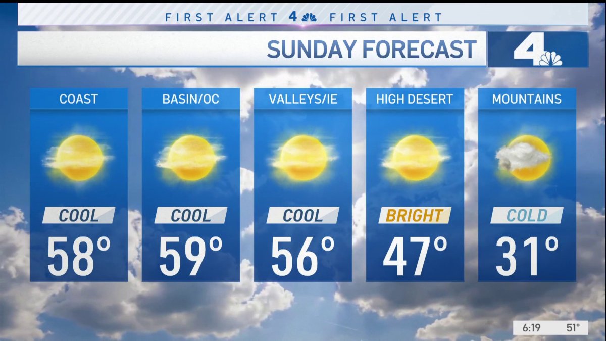
A winter storm warning was issued from 4 p.m. Saturday to 10 a.m. Sunday in the mountains. The warning was cancelled by 7 a.m. Sunday.
Snow level was expected to get as low as 3,500 feet.
More rain is expected next week.
The second in a series of holiday week storms brought a gift for anyone dreaming of a wet and snowy Christmas in Southern California.
Steady rain pushed into the region from the central California coast. The heaviest rain is expected Saturday night.
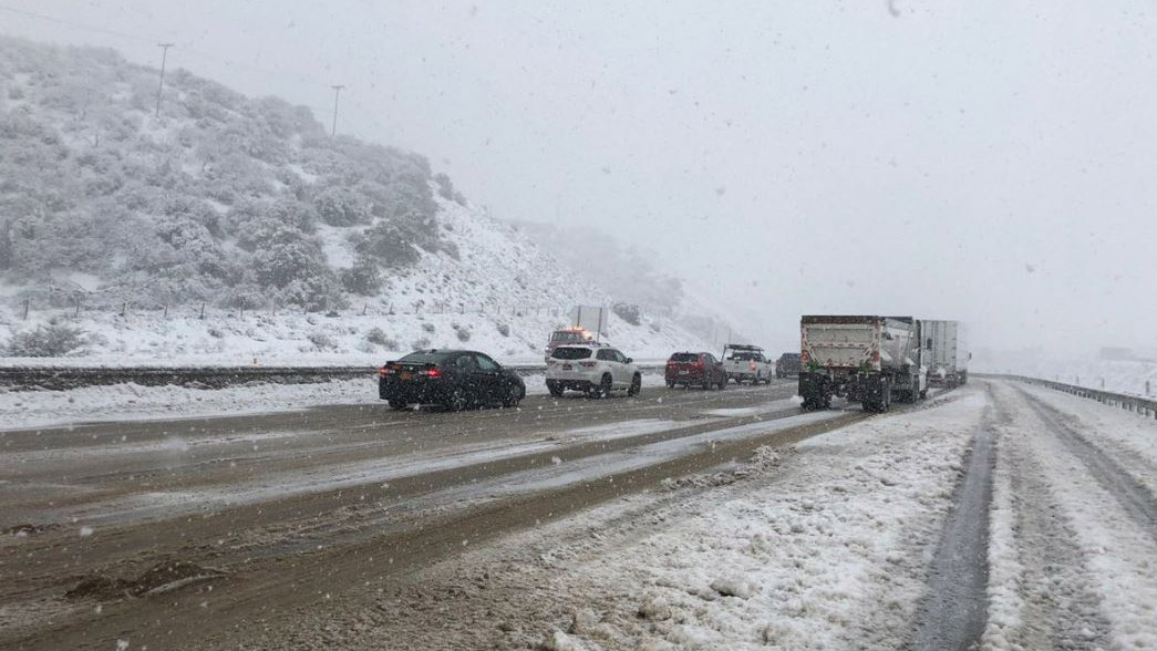
A winter storm warning was issued from 4 p.m. Saturday to 10 a.m. Sunday in the mountains, where the snow level was expected to get as low as 3,500 feet. Six to 12 inches of snow were expected above 5,000 feet.
As of 7 a.m. on Sunday, the winter storm warning was cancelled.
The system will move through the region fairly quickly, with just lingering snow showers on the north facing mountain slopes by Sunday morning.
Caltrans
The State Highway 89 roundabout in Tahoe City is pictured Thursday Dec. 30, 2021.
NBCLA
The 5 Freeway was closed north of Los Angeles Thursday Dec. 30, 2021.
FOREST FALLS, CA – DECEMBER 28, 2021: Sam Richey, 15, of Forest Falls gets some air-time while using a Boogey board to sled on fresh snow from Mondays winter storm on December 28, 2021 in Forest Falls, California.(Gina Ferazzi / Los Angeles Times via Getty Images)
Getty
Tustin, CA – December 26: Sun and clouds paint the sky over Orange County on Sunday, December 26, 2021 as storms are expected to close out the year. Rain and snowfall of 4 to 8 inches is anticipated at elevations above 4,000 feet and up to 16 inches above 6,500 feet Monday into Tuesday. (Photo by Mindy Schauer/Digital First Media/Orange County Register via Getty Images)
NBCLA
Snow in the mountains east of Los Angeles Wednesday Dec. 29, 2021.
FOREST FALLS, CA – DECEMBER 28, 2021: A man takes a selfie amidst the snow covered San Bernardino National Forest after Mondays winter storm dropped snow to the 5,000 foot level blanketing Forest Falls in a white winter scene on December 28, 2021 in Forest Falls, California.(Gina Ferazzi / Los Angeles Times via Getty Images)
Torrance, CA – December 28: With a break from the rain but cold temperatures and bright sun, the ocean almost looks like snow at the beach in Torrance on Tuesday, December 28, 2021. Showers are forecasted to return Wednsneday and Thursday but New Year”u2019s Eve celebrations should be under clear skies. (Photo by Brittany Murray/MediaNews Group/Long Beach Press-Telegram via Getty Images)
CHP
A storm closes part of Interstate 80 in the Sierra Nevada Mountains Dec. 25, 2021.
Caltrans
Caples Lake Maintenance crews clear snow on State Route 88 on Christmas Eve in Alpine County.
Caltrans
Caltrans crews clear snow in the mountains of Inyo County on Christmas Day.
Silverado Canyon, CA – December 24: A mudslide-covered propane tank sits along Silverado Canyon Road in Silverado, located in eastern Orange County, following an overnight storm, on Friday, December 24, 2021. The December 2020 Bond fire burned much of the the area and left the hills above the canyon barren and vulnerable rock-filled mudslides. (Photo by Mark Rightmire/MediaNews Group/Orange County Register via Getty Images)
SILVERADO CANYON, CA – DECEMBER 23: Jay Parker, 40, stands where his yard was washed away, the hot tub covered with mud and oak trees were toppled by a flash flood during last weeks storm along the 28000 block of Silverado Canyon Road on Thursday, Dec. 23, 2021 in Silverado Canyon, CA. (Gary Coronado / Los Angeles Times via Getty Images)
Caltrans
Caltrans crews clear snow in the mountains of Inyo County on Christmas Day.
Getty Images
Los Angeles, CA – December 23: Cars drive through a rain flooded intersection at Chastsworth St and Haskell Ave in Granada Hills, CA, Thursday, Dec 23, 2021. (Photo by Hans Gutknecht/MediaNews Group/Los Angeles Daily News via Getty Images)
Los Angeles, CA – December 23: A pedestrian makes his way along Van Nuys Blvd at Arleta Ave in Arleta, Thursday, Dec 23, 2021. (Photo by Hans Gutknecht/MediaNews Group/Los Angeles Daily News via Getty Images)
LOS ANGELES, CA – DECEMBER 21: Snowcapped mountains are seen in the distance from City Terrace on the first day of winter in Pasadena on Tuesday, Dec. 21, 2021 in Los Angeles, CA. A series of storms spinning off the coast of Northern California are gathering strength and will soon begin moving toward the lower part of the state, the National Weather Service said. (Dania Maxwell / Los Angeles Times via Getty Images)
Calttrans
A damaged stretch of State Route 18 in the San Bernardino County mountains Friday Dec. 24, 2021.
Caltrans
Part of State Route 18 in the San Bernardino County mountains was closed in both directions.
Caltrans
A view of traffic on Interstate 80 near Donner Summit on Dec. 24, 2021.
Silverado Canyon, CA – December 24: Crews work at cutting up a large tree that fell across Silverado Canyon Road in Silverado, located in eastern Orange County, early Friday, December 24, 2021, following overnight storm that brought heavy rain and wind, knocking over a utility pole as it fell. The canyon areas are under mandatory evacuations following overnight storms that brought heavy rain and mudslides. The December 2020 Bond fire burned much of the the area and left the hills barren and vulnerable rock-filled mudslides. (Photo by Mark Rightmire/MediaNews Group/Orange County Register via Getty Images)
Getty
SANTA MONICA, CA – DECEMBER 24, 2021 – – A passing storm makes its way above people who play in the surf on Christmas Eve in Santa Monica on December 24, 2021. (Genaro Molina / Los Angeles Times via Getty Images)
Silverado Canyon, CA – December 24: An evacuation order sign on East Santiago Canyon Road in Orange informs motorists that the canyon areas of eastern Orange County are under mandatory evacuations following overnight storms that brought heavy rain and mudslides to the area, on Friday, December 24, 2021. The December 2020 Bond fire burned much of the the area and left the hills above the canyon areas barren and vulnerable rock-filled mudslides. (Photo by Mark Rightmire/MediaNews Group/Orange County Register via Getty Images)
OAKLAND, CALIFORNIA – DECEMBER 23: Workers clear a mudslide from a double lot in the 6300 block of Westover Drive in Oakland, Calif., on Thursday, Dec. 23, 2021. More rain is expected through the holiday weekend according to the National Weather Service. (Jane Tyska/Digital First Media/East Bay Times via Getty Images)
Caltrans
Snow covers Interstate 80 in Northern California’s Placer County.
Getty
OAKLAND, CALIFORNIA – DECEMBER 23: Storm clouds are seen over San Francisco in this view from Oakland, Calif., on Thursday, Dec. 23, 2021. (Jane Tyska/Digital First Media/East Bay Times via Getty Images)
Jessica Samet
A downed pine tree in Cheviot Hills Friday Dec. 24, 2021
Caltrans
A view of the 101 Freeway in San Luis Obispo on Dec. 23, 2021.
Sequoia and Kings Canyon National Parks
A rockslide in Sequoia National Park.
Sequoia and Kings Canyon National Parks
A snowy scene in Grant Grove in Kings Canyon National Park.
AP Photo/Jeff Chiu
Pedestrians carry umbrellas as they walk past a large holiday tree outside of the Chase Center in San Francisco, Dec. 22, 2021.
The storm is expected to be colder but less moist than the system that hit the area Thursday and Friday, which dropped between 1.5 and 3 inches.
Saturday's rain will produce between .5 and 1 inches for most areas, with up to 1.5 inches in favored foothill/mountain locations. In the mountains, a winter storm warning was issued from 4 p.m. Saturday to 10 a.m. Sunday.
Here's the storm timeline of when the heaviest rain is expected.
Late Saturday in Los Angeles County.
Around midnight in the San Gabriel Valley and Orange County.
After midnight in the Inland Empire.
The snow level was expected to get as low as 3,500 feet, with 6 to 12 inches of snow expected above 5,000 feet. Saturday's high temperatures will be in the upper 40s and 50s, with lows dropping into and 30s in some valley and mountains areas, and the high 20s in the Antelope Valley.
Wind gusts of up to 45 miles an hour are expected in the mountains and high desert.
Rain soaks Southern California, flooding roads and causing evacuations in Orange County canyon areas. As reported on Thursday, Dec. 23, 2021.
Looking Ahead to Next Week's Weather
Another significant rainstorm is forecast for Monday, with .5 to 1 inch of rain expected in a fast-moving system with the potential for more.
Snow levels could drop below 2,500 feet Tuesday, with a dusting in the foothills.
The next storm after that will affect the region from late Tuesday night into Thursday, with another system quickly moving in from the north Friday.
New Year's Day was shaping up to be dry but cool across the region, though the forecast could still change between now and then.
The Bigger Picture for California's December Weather
In October, the National Oceanic and Atmospheric Administration announced that a the Pacific Ocean was showing signs of a new La Nina, the flip side of the El Nino ocean-warming pattern, that tends to cause changes in weather worldwide.
Forecasters said much of California would have a 33% to 50% chance of below-normal precipitation, while only the state's far northern tier had equal chances of above- or below-normal precipitation.
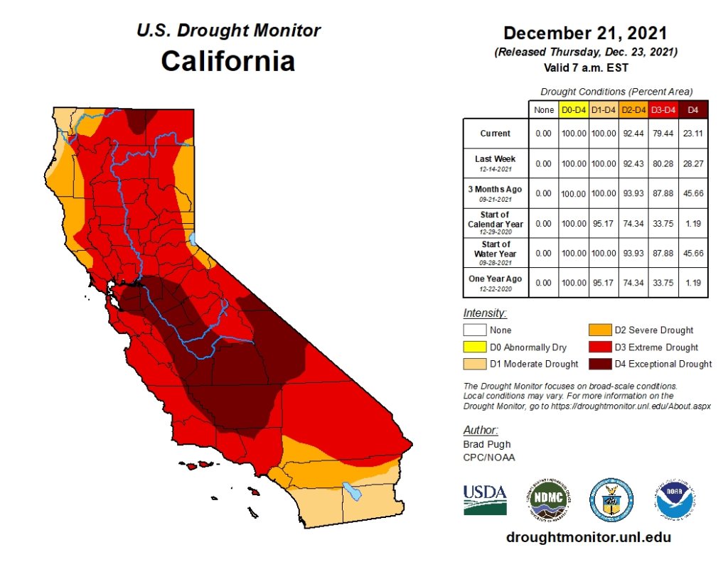
US Drought Monitor
The California Drought Monitor map for Dec. 21, 2021.
But the storm track has trended farther south than is usual during La Ninas. After a series of mid-December tempests, California's overall snow-water equivalent — a measurement of how much water is in the snowpack — jumped from 19% of normal to date on Dec. 10 to 76% of normal on Dec. 17, according to the latest U.S. Seasonal Drought Outlook.
While the current wet trend is positive, it is too early to know if it will last through January and February. The snowpack normally doesn't reach its maximum until April and last spring there was minimal runoff because much of the water was absorbed by the drought-parched landscape.