In March 1928, the St. Francis Dam disaster sent water on a rampage in Southern California
More than 450 people were killed in the March 1928 St. Francis Dam collapse, a civil engineering failure that unleashed an avalanche of water across Southern California
By Jonathan Lloyd
By Jonathan Lloyd
This article was originally published March 11, 2019.
In March 1928, the worst civil engineering failure in California history killed more than 450 people when a wall of water carved a path of staggering destruction from a canyon north of Los Angeles to the coast.
Click here for historic photos of the St. Francis Dam and the aftermath of its collapse.
The St. Francis Dam in San Francisquito Canyon, about 40 miles northwest of Los Angeles, collapsed just before midnight on March 12, 1928. The breach unleashed 12 billion gallons of water that spread across the region, carrying mud and debris through towns and farming communities. The terrifying rampage of water and debris lasted more than five hours and stretched to the Pacific Ocean in Oxnard.
USGS/Photo courtesy of the Los Angeles Bureau of Power and Light
A view of the St. Francis Dam north of Los Angeles before the 1928 disaster that left more than 450 people dead.
ASSOCIATED PRESS
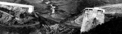
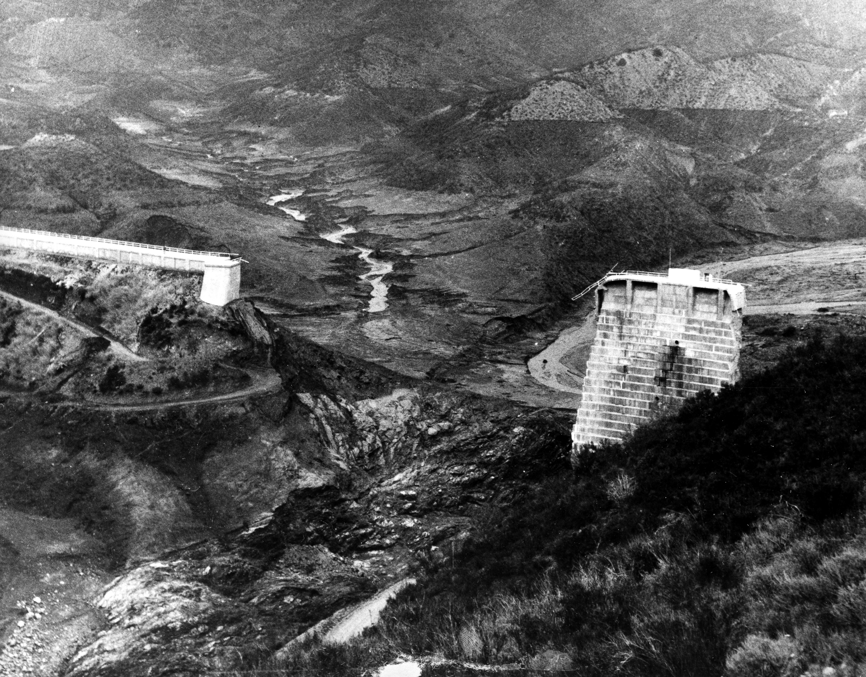
This aerial view shows the broken water barrier of San Francisquito Canyon, Ca., after the St. Francis Dam burst on March 13, 1928. The dam's reservoir of 12.5 billion gallons of water poured down the narrow canyon, carrying nearly hundreds to their deaths. (AP Photo)
USGS/
This photo provides a view downstream toward the former location of the west abutment of the St. Francis Dam. The photo was taken March 17, 1928, nearly a week after the dam's collapse.
Jonathan Lloyd/KNBC-TV
A view of San Francisquito Canyon, site of the March 1928 St. Francis Dam collapse. the dam site is about a half-mile north of a victims memorial off San Francisquito Canyon Road. The site can be located by looking for mostly buried strips of concrete. Photo taken March 2018.
USGS
A concrete block is pictured from the west abutment of the St. Francis Dam. The block is about 63 feet long, 30 feet high, and 54 feet wide. The dam wing wall can be seen in the distance. March 17, 1928.
Jonathan Lloyd/KNBC-TV
A view of San Francisquito Canyon, site of the March 1928 St. Francis Dam collapse. the dam site is about a half-mile north of a victims memorial off San Francisquito Canyon Road. Photo taken March 2018.
USGS
This March 17, 1928 photo shows a view looking downstream of enormous cement blocks at the base of the St. Francis Dam's east abutment. Dust clouds can be seen in the background from landslides that were still in progress five days after the dam's failure.
USGS
This March 18, 1928 photos whos damage left behind in Santa Paula by water unleashed when the St. Francis Dam collapsed near Santa Clarita March 12, 1928.
USGS
This March 18, 1928 photo shows damage in Santa Paula, devastated by water after the March 12, 1928 St. Francis Dam collapse north of Santa Clarita, about 30 miles away.
USGS
This March 17, 1928 photo shows the remains of the St. Francis Dan and the reservoir floor after the dam collapsed March 12, 1928.
USGS
This March 18, 1928 photo shows a house pushed onto its side in Santa Paula by water from the collapsed St. Francis Dam, located about 30 miles to the east.
USGS
This photo taken March 18, 1928 shows a washed out highway between Castaic and Piru after the collapse of the St. Francis Dam in Santa Clarita.
USGS
Houses and debris are piled up in Santa Paula due to floodwaters that rampaged across the region after the collapse of the St. Francis Dam near Santa Clarita. Photo taken March 18, 1928.
USGS
The powerful wall of water that crashed across the region following the St. Francis Dam collapse was strong enough to twist this railroad track between Castiac Junction and Piru. Photo taken March 18, 1928.
USGS
Powerful floodwaters that swept across the region after the collapse of the St. Francis Dam lifted a railroad track and dropped it on this road between Castaic Junction and Piru. Photo take March 18, 1928.
USGS
Large blocks of concrete from the St. Francis Dam were scattered about one-third of a mile downstream after its collapse on March 12, 1928. A tractor can be seen in the foreground. Photo taken March 17, 1928.
USGS
This March 17, 1928 photo shows the remains of homes near Power Plant 2 in a tributary valley of San Francisquito Canyon, site of the March 12, 1928 dam collapse and flood. Eleven bodies were removed from the debris seen here.
Jonathan Lloyd/KNBC-TV
California Historical Landmark No. 919 is about a half-mile south of the site of the St. Francis Dam collapse in March 1928.
Jonathan Lloyd/KNBC-TV
A memorial next to San Francisquito Power Plant No. 2 on San Francisquito Road is dedicated to the victims of the March 1928 St. Francis Dam collapse.
Jonathan Lloyd/KNBC-TV
San Francisquito Power Plant No. 2 is part of the water system that brings water from the eastern Sierra Nevada Mountains to Southern California. Pipes can be seen behind the station.
Jonathan Lloyd/KNBC-TV
A view of a memorial for the March 1928 St. Francis Dam collapse victims as seen off San Francisquito Road north of Santa Clarita.
USGS/Jonathan Lloyd/KNBC-TV
A memorial next to San Francisquito Power Plant No. 2 on San Francisquito Road is dedicated to the more than 450 victims of the March 12, 1928 St. Francis Dam disaster.
The man-made flood marks the second-largest loss of life in a single disaster in California. Only the 1906 San Francisco earthquake accounted for more fatalities.
St. Francis dam construction began in 1924 at a location that is upstream from what is now the Six Flags Magic Mountain theme park in Valencia. The dam reached a height of 205 feet and a width of 1,300 feet when the concrete barrier, a key piece of Los Angeles chief water engineer William Mulholland's water system that transformed the city into what it is today, was completed two years later.
Water supplied from the Los Angeles Aqueduct, which allowed water to flow south from reservoirs in the eastern Sierra Nevada Mountains to the dry southern part of the the state, entered the dam in May 1926, giving Los Angeles a reserve system that could last at least a year.
A look back at the St. Francis Dam disaster of March 1928. More than 400 people were killed when water burst through the leaky dam and roared across a widespread part of the area northwest of Los Angeles. Conan Nolan reports for NBC4 in November 1999.
It appeared Mulholland had achieved governance over nature -- but there were early signs that was only a fantasy.
Residents and workers near the dam, including damkeeper Tony Harnischfeger, noticed problems from the start. Harnischfeger, who lived below the dam with his family in a small cottage, called Mulholland to the site to inspect a muddy leak, according to the Los Angeles Times.
Mulholland's chief assistant declared there was no threat from the leak following the inspection.
A few hours later at about midnight, the Harnischfegers were among the first to die when a wall of water roared down on the canyon. The water carried debris, boulders, mud, trees and anything else in its path away in an unrelenting wave. Hundreds of houses, bridges, roads and other buildings were destroyed, according to the California Department of Water Resources. The force of the water and debris was so powerful, it twisted a stretch of railroad track between Castaic Junction and Piru.
This aerial view shows the broken water barrier of San Francisquito Canyon after the St. Francis Dam burst just before midnight on March 12, 1928. The dam's reservoir of 12.5 billion gallons of water poured down the narrow canyon, carrying hundreds to their deaths. (AP Photo)
An estimated 37.5 square of farmland was swept away. The avalache of water flowed into the Santa Clara Riverbed and followed it through several towns, including Filmore, Santa Paula and Castaic. There was nothing resembling an advanced warning system, which might have provided residents downstream from the rush of water with time to evacuate. Instead, telephone operators called communities in the water's path and motorcycle officers raced ahead to communities in jeopardy, the Los Angeles Times reported.
The water continued on its deadly path until around 5:30 a.m. a day later.
All that remained of the dam was a single column, standing like a tombstone among the devastation. That section, featured in a front-page photo in the March 14, 1928 Los Angeles Times, was later blasted to pieces.
The death toll was estimated at more than 450, but experts say that figure could be much higher. Bodies were discovered years after the collapse, others were washed out to sea.
The construction of a municipal dam should never be left to the sole judgment of one man, no matter how eminent.
Jury Statement
The saga marked what was effectively the end of Mulholland's storied career, one that forever left its mark on Los Angeles' water infrastructure. When he testified at the coroner's inquest, Mulholland said, "I envy the dead."
The inquest jury did not recommend prosecution, but heaped blame on Mulholland for the disaster.
"The construction of a municipal dam should never be left to the sole judgment of one man, no matter how eminent," the jury said.
A state commission later determined that the dam was poorly built in a geologically unstable site. A year after the disaster, lawmakers created what would become the Division of Safety of Dams under the California Department of Water Resources. The division's geologists and engineers review and approve dam construction plans and conduct regular inspections.
A memorial next to San Francisquito Power Plant No. 2 on San Francisquito Road is dedicated to the victims. California Historical Landmark No. 919 is about a half-mile south of the site of the dam, which can be located by looking for mostly buried strips of concrete.
In February 2019, the U.S. Senate approved the creation of a new national monument for the site. Designs for a memorial managed by the U.S. Forest Service in honor of the St. Francis Dam disaster victims are being considered.
Designs for a memorial in honor of the St. Francis Dam disaster victims are being considered. Video broadcast Tuesday Feb. 1, 2021 on the NBC4 News.