
What to Know
- A cold system will bring rain, powerful winds and mountain snow Tuesday and Wednesday.
- The snow level will drop to about 4,000 feet, piling on to what was already there in mountain communities.
- Expect 1 to 3 inches of rain for most areas. Mountain and foothill communities will see more.
The National Weather Service issued a brief tornado warning Tuesday night for central Ventura County and southwestern Los Angeles County. The warning expired at 8:30 p.m.
The warning area included Casa Conejo, Lake Sherwood and Solromar.
Get Southern California news, weather forecasts and entertainment stories to your inbox. Sign up for NBC LA newsletters.
A tornado warning means that a tornado is imminent and presents "imminent danger to life and property," according to the NWS.
During a tornado, people should move to an interior room on the lowest floor of a "sturdy" building while trying to avoid windows, according to the NWS. Cars are not considered safe and those inside of one at the time of a tornado should try to drive to a shelter or ditch their car entirely and look for a low-lying area such as a ditch or a ravine.
(Story continues below).
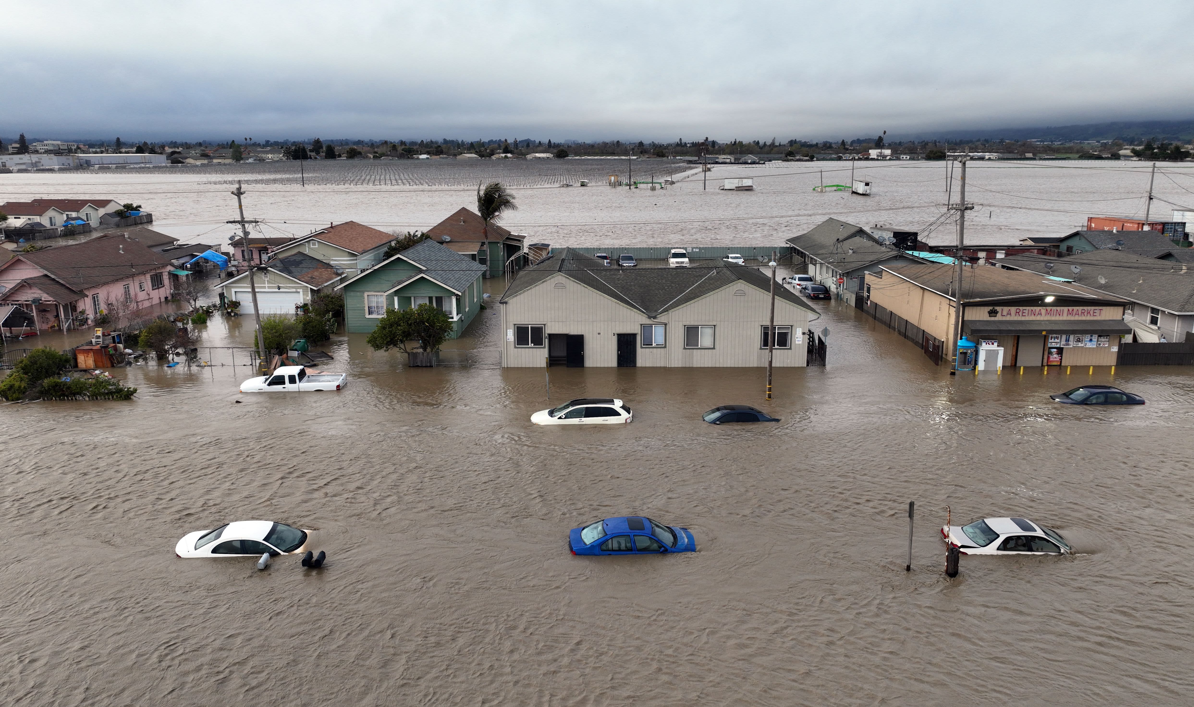
A large swath of Southern California is under a flood watch as a strong cold storm has moved into the region, bringing rain, snow and gusty winds.
The two-day storm, the latest in a series of wet weather systems since late February, will be coming in a few waves that will begin Tuesday morning and last until Wednesday.
Send Us Your Snow and Rain Weather Photos
"Flooding is a possibility," said NBC4 forecaster Belen De Leon. "Other big impacts are going to be strong winds. It's also going to bring us a lot of snow."
There are many residents that are still trying to recover from other recent storms that caused dangerous mudslides and this storm is bringing similar conditions.
March Storm Timeline
The first wave of rain made its appearance around midnight and early Tuesday morning, so drivers were hit with slick roads. Rain will continue through the early part of the day, starting off light to moderate before heavier downpours between 7 a.m. and 11 a.m.
"This widespread heavy to moderate rain is going to be with us at least through the middle of the morning," said De Leon.
The second wave will move in after lunchtime and continue into the evening. This wave will bring significantly heavy rainfall, and there is also the possibility of thunderstorms.
The third wave will start Tuesday night and continue into Wednesday morning. By this time the rain will become more scattered through the region but will remain moderate to heavy.
The coast and the valleys are expected to see anywhere from 1 to 3 inches of rain. Mountains and foothill areas can expect more.
Unlike the last two previous storms that were caused by warm atmospheric rivers, this storm will bring colder air meaning snow levels will drop.
Severe Weather Alerts
Yucaipa police issued an evacuation warning for Oak Glen, Forest Falls, Mountain Home Village, Angelus Oaks, and Northeast Yucaipa starting at 8 p.m. over a potential for mud and debris flow.
A flood watch was expanded for most of Southern California for Tuesday and Wednesday.
A winter storm watch and high wind watch will go into effect Tuesday morning and will remain until Tuesday night and Wednesday evening.
Wind gusts could reach 30 to 60 mph for most of LA County and be around 40 to 70 mph in the desert areas.
Officials warn residents about downed power lines and tree which could make it dangerous to drive and travel in.
Residents are encouraged to avoid unnecessary travel and be prepared to take action if flooding in certain areas becomes dangerous.
The storm-related weather could cause dangerous conditions like roadway flooding along with urban and small stream flooding.
The combination of old snow and new snow will elevate the avalanche danger above 6,000 feet.
Snow drifts and other winter hazards forced the closure of roads in the San Bernardino National Forest in Riverside and San Bernardino counties. The U.S. Forest Service said extreme snowfall at higher elevations has led to rain and snow melting at lower elevations, making driving treacherous on some roads. The closure order affects about 50 forest-maintained roads, some of which lead to campgrounds, picnic areas, and hiking areas, but those areas should be cleared.
"We are seeking to make as much of the forest once again accessible to visitors as possible," the USFS said.
Some tips to remember when driving in a storm:
- Drive at lower speeds
- Allow for more time to arrive to your destination
- Check brakes, tire pressure and windshield wipers
- Leave more space between you and other vehicles
