
An evacuation warning was issued for residences bordering Pacific Coast Highway in Ventura due to high surf impacting structures.
The warning stretches for homes in between Seacliff Avenue South to Emma Wood Group Camp.
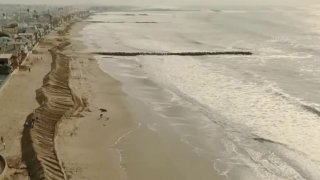
The Ventura County Fire Department is urging people to stay clear of the coastal areas during the storm and high surf warning.
All City, State, and County beaches and parks along the coastline are closed.
Get Southern California news, weather forecasts and entertainment stories to your inbox. Sign up for NBC LA newsletters.
An EVACUATION WARNING has been issued for residences bordering Pacific Coast Highway, from Seacliff Avenue South to Emma Wood Group Camp, due to high surf impacting structures in the area.
— VCFD PIO (@VCFD_PIO) December 30, 2023
The ventura County fire department is encouraging individuals to avoid the coastal areas… pic.twitter.com/ebivoZd7l0
Parts of Los Angeles County experienced flooding this morning as a strong one-day rainstorm hit the area, creating dangerous conditions on roads and at beaches.
A flood advisory was in effect until 11 a.m. for a portion of southwest California, including central and southern Los Angeles County, and far eastern Ventura County, according to the National Weather Service.
Local


Local law enforcement agencies reported some urban and small stream flooding in the advisory area. Some locations that were warned about possible flooding include Long Beach, Malibu, Griffith Park, Hollywood, downtown Los
Angeles, Universal City, Burbank, Beverly Hills, North Hollywood, Culver City, Alhambra, Inglewood, Pasadena, Van Nuys, Venice, Santa Monica and Encino.
The NWS also issued a special weather statement for the areas of Santa Clarita, Newhall and San Fernando, where winds up to 50 mph were expected.
Meanwhile, a high surf warning was in effect until 10 p.m. Saturday for all Los Angeles County beaches, including the Malibu Coast and Catalina Island.
"Significant flooding of sea water is likely over vulnerable low-lying coastal areas around the time of high tide," according to the NWS.
"Damage to coastal roadways and structures is possible. Powerful waves and strong rip currents will pose an exceptional risk of ocean drowning and damage to coastal structures like piers and jetties. Large breaking waves can cause injury, wash people off beaches and rocks, and capsize small boats near
shore."
The large waves were expected to create dangerous conditions for anyone entering the water with the possibility of flooding in areas close to the beach.
Forecasters warned that the county will continue to see waves of 10 to 15 feet, with some reaching as high as 20 feet, accompanied by dangerous rip currents.
The highest surf was anticipated at west-facing beaches such a Hermosa, Manhattan and Palos Verdes, forecasters said.
Due to safety concerns relating to the high surf and ocean swell, the Manhattan Beach Pier will be closed through Sunday, city officials said.
Los Angeles County health officials issued an ocean water quality rain advisory until at least 6 a.m. Tuesday, advising people to avoid all water contact, especially near discharging storm drains, creeks, and rivers due to potentially higher bacteria levels in these areas.
Long Beach issued a rain advisory and said recreational swimming areas should be avoided. City officials also urged residents and visitors to drive carefully through the area. Residents in low-lying areas such as Alamitos Bay were urged to "be vigilant and prepare for potential localized flooding due to the large swells."
Sand and sandbags were being made available to residents at city fire stations.
NWS forecasters added: "Stay off of beaches and coastal walkways, roads, and structures. Do NOT drive around barricades or through water of unknown depth. Everyone should remain out of the water due to life-threatening surf conditions. Stay off of jetties, piers, and other water side infrastructure."
In Orange County, a high surf warning and coastal flood advisory will be in effect until 2 a.m. Monday. Forecasters said Orange County beaches will see waves of 6 to 15 feet.
According to the NWS, the Orange County locations most susceptible to flooding include Seal Beach, Sunset Beach and Newport Beach.
The high surf was the result of "powerful cyclones over the northern Pacific waters," according to the NWS. The waves were expected to ease a bit Friday night before a another "strong wave front" arrives Saturday morning.
Conditions are expected to dry out Saturday night and Sunday morning, though very light rain is possible on New Year's Day.
Forecasters said the system will likely only produce less than a tenth of an inch of rain, meaning the Rose Parade should escape any major downfalls, although the NWS conceded the day's forecast "is still pretty iffy."
The area will dry out again Tuesday, with another brief storm system predicted to arrive Wednesday.
