
NASA scientists have potentially found accessible ice on Mars, a promising development for possible future human expeditions to the Red Planet.
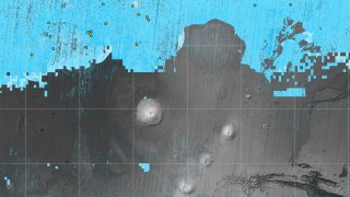
The NASA-funded Subsurface Water Ice Mapping project (SWIM) recently released its most detailed set of maps showing subsurface ice since the project began in 2017. Previous maps used lower-resolution imagers, radar, thermal mappers and spectrometers. The new images come from higher-resolution cameras, delivering a detailed perspective on the presence of ground ice.
Previous versions only hinted at the presence of buried ice.
“Astronauts or robots could one day drill ice cores, uncovering the climate history of Mars and exploring potential habitats (past or present) for microbial life," JPL said in on its website.
Get top local stories in Southern California delivered to you every morning. >Sign up for NBC LA's News Headlines newsletter.
The SWIM project uses data from several NASA missions, including the Mars Reconnaissance Orbiter, and other technologies to develop imagery showing the likeliest places to find Martian ice that can be accessed from the surface.
The reason scientists need to find subsurface ice is because water on Mars' surface immediately vaporizes due to the planet's thin atmosphere, according to NASA.
The buried ice could be drinkable and may also serve as an ingredient for rocket fuel, JPL says. NASA first discovered ice on Mars’ north pole in 2008, unveiling the extreme environmental conditions in the region.
Local
Get Los Angeles's latest local news on crime, entertainment, weather, schools, COVID, cost of living and more. Here's your go-to source for today's LA news.


“Those regions are too cold for astronauts (or robots) to survive for long,” JPL said.
Instruments detected what looks like subsurface frozen water along the planet's mid-latitudes. The northern mid-latitudes are especially promising due to a thicker atmosphere, making it easier to slow a spacecraft as its descends for landing. Ideal landing sites would be at the southernmost edge of the northern mid-latitudes where astronauts would be far enough north for ice to exist but close enough to the equator and warmer temperatures.
“If you send humans to Mars, you want to get them as close to the equator as you can,” said Sydney Do, JPL’s SWIM project manager. “The less energy you have to expend on keeping astronauts and their supporting equipment warm, the more you have for other things they’ll need.”
NASA will continue testing its mapping methods to find the precise location of ice.