
What to Know
- Wet and snowy conditions continue today.
- The wet weather ushers out after today.
- Don't travel to the mountains: there's a winter storm warning and advisory, making travel precarious.
After record rainfall amounts Sunday, the wet weather continued Monday as a storm swept over Southern California, with icy conditions making travel to the mountains very dangerous.
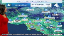
More isolated showers are expected Monday in Los Angeles County, and brr, it's going to be cold out there.
Monday is expected to be the coldest day of the week, NBC4 Today in LA meteorologist Belen De Leon said.
Get Southern California news, weather forecasts and entertainment stories to your inbox. Sign up for NBC LA newsletters.
"The chair lifts are running up in Big Bear, but we are changing the name. It's not Big Bear anymore, it's 'big BRRR,'" Belen De Leon said.
SoCal can expect snow in mountains and rain everywhere else, and the day will start off cold and stay that way, so bundle up.
Local
Get Los Angeles's latest local news on crime, entertainment, weather, schools, COVID, cost of living and more. Here's your go-to source for today's LA news.


The center of the storm was just south of San Francisco around 5:30 a.m. PST, and a heavy round of rain was headed to Ventura County.
Pretty much everywhere in the region, it will be a chilly and soggy morning, with highs will about 10 degrees below normal. The afternoon will be drier.
On Sunday, the storm brought 1.21 inches of rain near the Hollywood Burbank Airport, breaking a record of 1.09 inches set for the day in 1996. Lancaster saw 0.46 inches of rain, breaking a 1993 record.
Avoid travel to mountains
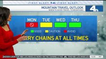
There will be better travel opportunities Tuesday to the mountain areas. Currently, there is a Winter Storm Warning in effect until 10 p.m. There is also an Advisory through Tejon Pass and Antelope Valley.
Heavy snow and windy conditions are expected above 5,000 feet, with snowfall expected to amount to 4-8 inches. This will make the drive difficult, so if you can avoid traveling to mountain areas Monday, delay your trip, and always remember to bring the snow chains.
Overnight, snow stranded drivers on Highway 18 from Running Springs to Big Bear.
Snow also forced road closures in the Angeles National Forest: sections of Angeles Forest Highway, and Big Tujunga Canyon Road.
The Rim of the World Unified School District in the mountain community of Crestline was also calling Monday a snow day.
"ALERT! Due to the pending storm and its impact on the mountain area, today, December 12th is a snow day, no school," a notice on its website read.
Slow warmup after Monday
The wet weather will usher out after Monday, and temps will start to climb, so there will be sunshine by Friday. It will be about 12 degrees warmer by the end of the week, but it's still December, so it will be colder than usual. Remember to layer!
