What to Know
- Steady overnight rain causes flooding and forces roads closures in Southern California.
- The slow speed of the storm means there are flooding concerns, continuing into Thursday.
- The Grapevine section of the 5 Freeway north of Los Angeles was closed for hours due to snow and ice.
An early winter storm unleashed hours of rain and snow in Southern California, leading to flooding and slides in Malibu, evacuations in some fire-scarred canyons and the closure of a major freeway in northern Los Angeles County.
Rain started over Ventura County around 9 a.m. Wednesday. The slow speed of the system means Los Angeles County didn't see its heaviest rain until around later that night.
And it just kept raining.
Get Southern California news, weather forecasts and entertainment stories to your inbox. Sign up for NBC LA newsletters.
"This line of rain is sitting over LA County, and the moisture is streaming up out of the south," said NBC4 forecaster David Biggar. "So, it really doesn't move anywhere. It just continues the heavy rainfall across the region."
The storm will stall in Los Angeles County for hours, bringing significant precipitation to the region all the way through Thursday morning and into the afternoon. With steady rain, debris flows and sides are possible in burn areas.
Rain will decrease late Thursday, dwindling to light showers overnight. Conditions dry out for the weekend.
Gov. Gavin Newsom declared a state of emergency in 20 California counties, including Los Angeles and Orange, in response to the storms. The proclamation "supports response and recovery efforts, including expanding access to state resources for counties under the California Disaster Assistance Act.''
The intense rains forced the closure of Six Flags Magic Mountain in Valencia. Knott's Berry Farm in Buena Park closed at 1 p.m. due to the downpours.
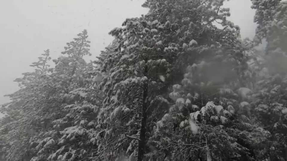
A winter storm warning was issued Tuesday night for San Bernardino County and Riverside County mountains, lasting until Thursday night. The snow level is expected to get as low as 5,000 feet, with between 6" and 1' of snow falling.
Heavy snow will fall in the area mountains the entire time. The snow will also be the longest-lasting part of the storm, continuing into Friday morning even after the rain has stopped for the rest of the region.
Storm Evacuations and Road Closures
Here are some of the major impacts from the storm.
- The 5 Freeway was closed early Thursday at Parker Road in Castaic. The road reopened at about 3:45 p.m.
- Steady overnight rain led to flooding at a campground in Leo Carrillo State Park in the Malibu area. The city said 22 people were rescued.
- State Route 23 is closed on the south end at State Route 1 (Pacific Coast Highway) due to mud and rock slides. Caltrans crews are checking the north end of SR-23 in Westlake.
- Two westbound lanes in the 27400 block of Pacific Coast Highway were closed due to a tree that fell.
- One westbound lane on Pacific Coast Highway, at Puerco Canyon Road, has been closed due to a mudslide, the sheriff's Lost Hills station reports.
- The Department of Transportation responded to a mudslide on Coldwater Canyon Road in Studio City, where cars were stuck in the mud.
- Mullholland Highway in the Santa Monica Mountains is closed between Las Virgenes Road and Cornell Road due to heavy mudslides and rockfall on the road. Maintenance crews from LA County Public Works are removing rocks, mud and debris.
- Both sides of Pacific Coast Highway are closed in Pacific Palisades due to a fallen tree that knocked down power lines, according to Caltrans. The southbound road is closed at Temescal Canyon Road, and the northbound side is closed at Chautauqua Boulevard.
Photos: December Storm Images From Around California
Rain, Snow and California's Drought
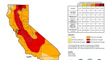
All of California remains is some level of drought this week, but conditions improved significantly in the two most severe categories.
The weekly report released Thursday shows exceptional drought was nearly erased after 23 percent of the state was under the most severe category one week ago. Nearly 33 percent of the state is in extreme drought, down from 79 percent last week.
In October, the National Oceanic and Atmospheric Administration announced that a the Pacific Ocean was showing signs of a new La Nina, the flip side of the El Nino ocean-warming pattern, that tends to cause changes in weather worldwide.
Forecasters said much of California would have a 33% to 50% chance of below-normal precipitation, while only the state's far northern tier had equal chances of above- or below-normal precipitation.
But the storm track has trended farther south than is usual during La Ninas. After a series of mid-December tempests, California's overall snow-water equivalent — a measurement of how much water is in the snowpack — jumped from 19% of normal to date on Dec. 10 to 76% of normal on Dec. 17, according to the latest U.S. Seasonal Drought Outlook.
While the current wet trend is positive, it is too early to know if it will last through January and February. The snowpack normally doesn't reach its maximum until April and last spring there was minimal runoff because much of the water was absorbed by the drought-parched landscape.