
A tropical storm delivered periods of heavy rain for hours Sunday and into the overnight hours, triggering widespread flash flood warnings as the remnants of a hurricane lashed the Los Angeles area.
Southern Californians woke up to gray skies and light rain early Sunday, ominous signs of what was to come when a tropical storm unlike any the area has seen for decades moved into the region. Hilary, once a Category 4 hurricane off the coast of Mexico, became a tropical storm Sunday.
The system delivered rare August rain throughout Sunday before weakening again Monday to a post-tropical cyclone, but not before shattering rainfall records.
Hilary's most severe rainfall was Sunday afternoon into the evening. Impacts from that rain could continue well into the overnight hours and Monday, including widespread flash flooding. Damaging winds are possible in some areas.
Get Southern California news, weather forecasts and entertainment stories to your inbox. Sign up for NBC LA newsletters.
No tropical storm has made landfall in Southern California since Sept. 25, 1939, when a system lost its hurricane status just before moving onshore in Long Beach. The results were catastrophic.
Early Sunday afternoon, Mother Nature had more in store for SoCal with a magnitude-5.1 earthquake centered in Ventura County. There were no reports of significant damage.
Check live updates on the storm's strength, location and aftermath below.
Monday 7 a.m.: Mud, rocks, debris block mountain roads
Heavy rain from a rare Southern California tropical storm triggered mud and rockslides Sunday that blocked roads in San Bernardino County mountain communities. In Forest Falls, a wave of boulders and large tree limbs rampaged down a hillside and onto a road near a fire station. A frightening deep rumble can be heard in video of the slide that shows people running for safety.
Monday 5:26 a.m.: Flooded roads strand cars in Sun Valley
Overnight rainfall pooled on a stretch of the 5 Freeway and an intersection Monday in Sun Valley, leaving vehicles stranded in water. About five vehicles were stranded in high water at 7:34 p.m. in the 11000 block of West Sherman Way at Hershey Drive. LAFD firefighters helped one person escape from the vehicle as waters continued to rise due to Tropical Storm Hilary.
All lanes were blocked early Monday on the southbound 5 Freeway in Sun Valley due to flooding at Lankershim Boulevard.
"Careful when you approach any of those roads," said NBC4 forecaster Belen De Leon. "It's still very soggy out there."
Monday 3 a.m. Rainfall records
The NWS announced rain totals in some parts of LA county. "Virtually all rainfall daily records have been broken thus far," the weather service said.
Some cities with historic rain totals as of 3 am include Lewis Ranch, 7.04 in; Lake Palmdale, 5.98 in; UCLA, 4.26 in; Thousand Oaks, 3.29; and Downtown LA, with 2.38 in.
Monday, 2:54 a.m: Flash flood warnings
Hilary was downgraded early Monday to a post-tropical cyclone as it moved north into Nevada.
Flash flood warnings remained in effect for San Bernardino and Riverside counties. Los Angeles and Ventura counties were under flood advisories.
Rain is in the morning forecast before conditions dry out in the afternoon.
Sunday 7:20 p.m.: Several schools announce closures
Bracing for potential damage brought upon by Tropical Storm Hilary, several school districts in Southern California announced they will be closed Monday.
Click here for a list of school districts that will be closed.
Sunday 5:47 p.m.: Pasadena Unified closes schools
Pasadena Unified School District (PUSD) announced it will close its schools Monday because of the storm.
"With the safety and well-being of our students, employees, and their families as our highest priority, we have decided to close PUSD schools tomorrow, Monday, August 21, 2023," the school district said in a statement. "We want everyone to stay safe and avoid any unnecessary travel or exposure to dangerous road conditions. This includes athletic events and any third-party activities on PUSD campuses."
Sunday 4:25 p.m.: LAUSD closes schools
LAUSD Superintendent Alberto Carvalho announced that the district's schools will be closed Monday due to the tropical storm.
Carvalho said the district is not in a position to keep campuses open because of the storm's timing. Authorities will not be able to determine whether schools buildings were damaged in the storm with impacts likely late Sunday or early Monday morning.
"Our inability to survey buildings, our inability to determine access to schools, makes it nearly impossible for us to open,'' Carvalho said during a late afternoon news conference. "The prudent thing to do to avoid harm or injury to any one child or workforce member of LAUSD is to call off school."
Sunday 2:41 p.m.: Hurriquake
A rare tropical storm wasn't enough for Mother Nature. A magnitude-5.1 earthquake rattled widespread parts of Southern California followed by at least a dozen aftershocks of magnitude-3.0 or greater. There were no significant reports of damage.
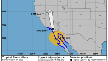
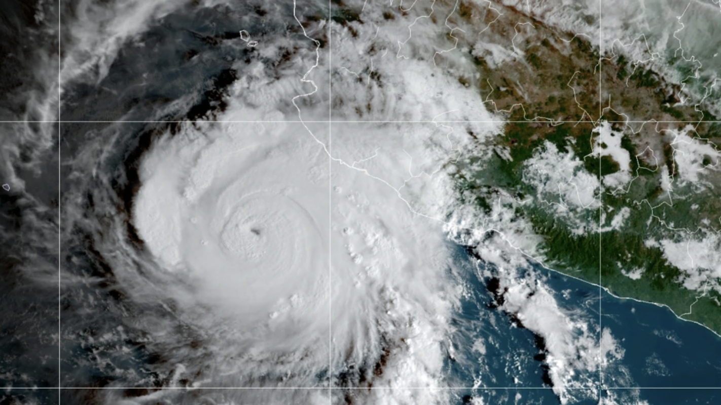
Sunday 2:06 p.m.: Core of Hilary nears Southern California
The core of Tropical Storm Hilary was nearing Southern California early Sunday afternoon. The most significant rainfall is expected Sunday afternoon into early Monday morning, according to the National Hurricane Center.
Sunday, 12:43 p.m.: Car pulled from LA River
What appeared to be an abandoned car was pulled from the Los Angeles River channel in Lincoln Heights. The LAFD, which had warned people to stay away from the river channel, said no occupants were found at the scene.
Sunday, 11:51 a.m.: Flash flood warning for LA County
A flash flood warning went into effect for Los Angeles County and parts of Ventura County. The warning, indicating a high threat of flash flooding, is in effect until 7:45 p.m.
The warning is for a large part of the Los Angeles area, including Long Beach, Santa Clarita, Glendale and other locations.
A second flash flood warning issued for the Antelope Valley will be in effect until 6:30 p.m.
Heavy downpours were reported in some locations. Rain may taper off at time, but then intensify again later Sunday, NBCLA forecaster David Biggar said.
"The storm is moving very fast," said Biggar. "It's moving at about 25 mph. It will not be making landfall in California, but it's moving from northern Mexico to us very shortly."
Sunday, 10:18 a.m.: School closures in Big Bear
Bear Valley Unified School District schools will close Monday due to the storm threat. The mountains of San Bernardino County are among the areas expected to see some of the most severe conditions.
Sunday, 8:54 a.m.: Residents urged to stay indoors
Los Angeles Mayor Karen Bass urged residents to stay inside Sunday with the city under a state of emergency.
"The city family has been working around the clock," LA Mayor Karen Bass said Sunday morning at a news conference. "Stay safe. Stay home. And, stay informed."
Bass said LAUSD Superintendent Alberto Carvalho will decide later Sunday whether to cancel classes Monday.
Sunday 7:54 a.m.: Hilary becomes a tropical storm
Hilary became a tropical storm early Sunday after it was downgraded from hurricane status. The designation means decreasing wind speeds, but the storm still carries the potential for heavy rain and possible flash flooding throughout Southern California.
Early Sunday the center of Hilary was just off the coast of northern Baja California with north-northwest movement at 21 mph. The storm produced maximum sustained winds of about 80 mph.
Sunday 7:28 a.m.: First rain from Hilary
The first rain from a storm unlike any seen in decades in SoCal arrived early Sunday. Hilary remains a Category 1 hurricane and was expected to become a tropical storm later Sunday morning with the potential to result in catastrophic and life-threatening flooding.
Forecasters and public safety officials have warned Southern California residents to stay home if at all possible Sunday due to the threat of severe weather.
Sunday, 4:42 a.m. "Catastrophic and Life-Threatening Flooding" in Baja California
The National Hurricane Center reported that Hurricane Hilary is already "very Near the West Coast of Baja California. Catastrophic and Life-Threatening Flooding Likely Over Baja California and Portions of the Southwestern U. S. Through Monday."
Saturday, 11:37 p.m.: LA Mayor Karen Bass declares local emergency
Los Angeles Mayor Karen Bass released a declaration of local emergency ahead of Hurricane Hilary's inclement appearance.
In preparation of potential power outages, downed trees and power lines, flooding and other damage, Mayor Bass issued the declaration to order "the Emergency Operations Organization (EOO) be immediately activated to take such steps that are necessary for the protection of life and property."
Saturday 8:30 p.m.: Hurricane Hilary downgrades to Category 1
Hurricane Hilary's downgraded to a Category 1 storm as it continued to take aim for the southwest region of the U.S. By the time it reaches Southern California, it's slated to weaken to a tropical storm.
Saturday 7:15 p.m.: Evacuation order for parts of San Bernardino County
The San Bernardino County Sheriff's Department announced an evacuation order for parts of the county. Impacted residents include those in:
- Oak Glen
- Forest Falls
- Mountain Home Village
- Angelus Oaks
- Northeast Yucaipa
Saturday 5 p.m.: State of Emergency in Southern California
A State of Emergency was declared in Southern California ahead of Hilary's expected arrival Sunday as a tropical storm. The declaration speeds response and recovery efforts.
The Governor signed the emergency proclamation in San Diego while visiting with California National Guard troops. Also today, the Governor met with first responders and local officials, including San Diego Mayor Todd Gloria. He also was in touch with federal officials, including the White House.
“California has thousands of people on the ground working hand-in-hand with federal and local personnel to support communities in Hurricane Hilary’s path with resources, equipment and expertise," Gov. Gavin Newsom said in signing the declaration in San Diego. "We’re mobilizing all of government as we prepare and respond to this unprecedented storm.”
Saturday 4:30 p.m.: Voluntary evacuation warning for parts of Santa Ana
A voluntary evacuation warning was issued for parts of Santa Ana as Orange County remains under a flood watch due to the impending storm. The voluntary evacuation warning was issued for residents in the Silverado Canyon and Williams Canyon in the Bond Fire burn area.
"Canyon residents are strongly encouraged to prepare and voluntarily evacuate on Saturday, August 19 at 4:30 pm, especially those with disabilities, access and/or functional needs, and canyon residents with large animals," the city said in a statement.
"Any person with disabilities and those with access and/or functional needs requiring evacuation assistance should call Orange County Sheriff’s Department Dispatch at 714-647-7000."
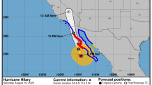
Saturday 2:00 p.m.: Hurricane Hilary changes to Category 2
As of 2:00 p.m. Saturday, Hurricane Hilary changed to a Category 2, according to the National Hurricane Center.
Under a Category 2, wind speeds can range from 96-110 mph.
Saturday, 11:46 a.m.: Evacuation warning in San Bernardino County
The San Bernardino County Sheriff issued an evacuation warning for the communities of Oak Glen, Forest Falls, Mountain Home Village, Angelus Oaks, and northeast Yucaipa due to the tropical storm system.
Saturday 11:25 a.m.: Chance of thunderstorms in Antelope Valley
According to the National Weather Service, there is a high chance of scattered thunderstorms in the Antelope Valley starting this afternoon around 3:00 to 5:00 p.m. and extending into the evening.
"Damaging winds, brief downpour, lightning and small hail are possible," the NWS said.
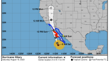
Saturday, 7:13 a.m.: Hilary speeds up
Category 3 Hurricane Hilary appears to be on track for an earlier than previously expected arrival in Southern California as a tropical storm. The heaviest rain is likely to begin Sunday and continue into the afternoon and evening.
“We are going to get a significant amount of rain and flooding is going to be the biggest threat," said NBC4 forecaster Shanna Mendiola.
The system also shifted slightly east, but remained on track for Southern California.
Thunderstorms began to pop up in the desert well east of Los Angeles due to Hilary’s outer bands.
In an update early Saturday morning, the National Hurricane Center said heavy rain will begin well in advance of the center of the storm. The storm was centered about 240 miles west-southwest of the southern tip of the Baja peninsula and moving north-northwest at 13 mph. The system was expected to turn more toward the north and increase speed.
Saturday, 5 a.m.: When will Hilary arrive in SoCal?
Hilary is expected to be downgraded to a tropical storm as it enters colder waters closer to the Southern California coast. When the rare tropical storm warning was issued Friday afternoon for Southern California, that indicated tropical storm conditions were expected within 36 hours. The timing places Hilary on track to deliver the most severe rain and wind in Southern California by Sunday afternoon and into Monday.
The National Hurricane Center predicted “catastrophic and life-threatening flooding” for the Baja California Peninsula and for the southwestern United States.
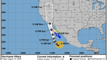
Hurricane Hilary
1-2 Rainfall forecast
Valid Aug. 20 through Aug. 22
Source: NOAA
“Do not go out from Sunday into the overnight hours,” said NBC4 forecaster David Biggar. “We are looking at seeing a lot of rainfall, and we could see some considerable flooding issues across some of our inland spots.”
Washed out roads are a concern in desert communities.
The west-central coast of the Baja California Peninsula is under a hurricane warning Saturday evening into Sunday morning.
Friday, 8:33 p.m.: Tropical storm warning for Southern California
The National Weather Service (NWS) upgraded its tropical storm watch to a warning for large parts of Southern California, particularly in Los Angeles and Ventura counties.
The agency said locations most likely to be impacted by the warning include Long Beach, Torrance, Santa Monica, Redondo Beach, Rancho Palos Verdes, Malibu and LAX. According to NWS, the tropical storm warning is forecasted to bring winds of 15 to 25 mph, with isolated gusts having the potential to reach 30 mph. The agency said the warning will be in effect through Monday.
NBC4 Meteorologist David Biggar said gusty winds are in store for the region Sunday, with rain slated to begin the same day. As of Friday evening, the peak of the storm is forecasted during Sunday afternoon and evening.
Impact on Sports
Bracing for inclement weather, several professional Southern California sports teams announced changes to their schedule.
The Los Angeles Dodgers, Los Angeles Angels, LAFC and LA Galaxy announced they are postponing their Sunday games. Both MLB teams will now have split doubleheaders Saturday while the soccer teams announced they are rescheduling their respective games.
Click here for details on the changes.
Friday, 4:06 p.m.
The flash flood risk increased across the region with considerable flooding likely for inland Southern California. All rivers, streams, creeks and arroyos will have water flowing through them. Some desert and mountain roads could be washed out by the remnants of Hilary.
Friday, 2:17 p.m.
A rare Southern California tropical storm watch was extended to all of LA County and portions of Ventura County. The watch issued earlier Friday was for parts of Los Angeles, Orange, San Bernardino and Riverside counties. The watch means tropical conditions are expected to start within 48 hours and includes Santa Catalina and Santa Barbara islands. Two rescue boats are normally stationed on the island, but county authorities said a third was added Friday.
The tropical storm watch is the first ever issued in Southern California, according to the National Weather Service.
Friday, 1 p.m.
Hilary is expected to strengthen more before it starts to weaken as it moves into colder waters near Southern California. The system is still expected to be a hurricane when approaching Mexico’s Baja California peninsula on Saturday night, then weaken to a tropical storm on Sunday.
The Mexican government said Hilary might brush a remote area on the western edge of the Baja California peninsula early Sunday. The government extended hurricane watches and warnings northward for parts of the Baja California peninsula A tropical storm watch was in effect for parts of mainland Mexico.
Friday, 9 a.m.
A rare Tropical Storm Watch was issued Friday for parts of Los Angeles, Orange, San Bernardino and Riverside counties. The watch means tropical conditions are expected to start within 48 hours.
The watch is for Catalina and Santa Barbara islands, the Antelope Valley foothills, San Gabriel Mountains, the 5 Freeway Corridor, Santa Clarita Valley, and Highway 14 Corridor, as well as much of the southern coastal waters.
The tropical storm watch is the first ever issued in Southern California, according to the National Weather Service.
"On the forecast track, a turn toward the northwest and north- northwest is expected (Friday) and tonight, followed by a faster motion toward the north Saturday night and Sunday," the National Hurricane Center's Friday morning advisory said. "The center of Hilary will move close to the west coast of the Baja California Peninsula over the weekend and reach Southern California by Sun night. Fluctuations in intensity are likely over the next day or so. Weakening is expected to begin by Saturday, but Hilary will still be a hurricane when it approaches the west coast of the Baja California peninsula Saturday night and Sunday. Hilary is expected to weaken to a tropical storm by Sun afternoon before it reaches southern California."
Friday Morning Update
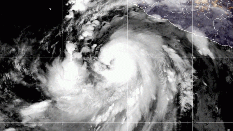
Hilary developed into a Category 4 hurricane by Friday morning. The powerful system was about 100 miles south of Socorro Island in Mexico and about 400 miles south of Cabo San Lucas on the southern tip of the Baja California Peninsula, according to a 5 a.m. advisory from the National Hurricane Center.
The system remains on track to become a tropical storm by the time it closes in on Southern California. Rainfall totals of 3 to 6 inches and isolated amounts of up to 10 inches are expected in parts of SoCal, including mountain communities.
"Hilary remains a large and powerful Category 4 hurricane," the National Hurricane Center advisory said. "Significant flooding impacts possible across portions of Baja California dn the Southwestern United States."
The hurricane's center was moving west-northwest at about 13 mph with maximum sustained winds of about 145 mph.
The storm will lose strength as it gets closer to Southern California and colder water with wind speeds decreasing from 120 mph early Saturday to 70 mph Sunday night and 40 mph by Monday evening.
Thursday Update
Early Thursday, Hilary was more than 1,000 miles away from Los Angeles, well off the southwest coast of Mexico. By Thursday afternoon, the system strengthened to a Category 2 hurricane off Mexico's Pacific coast, moving west-northwest at 14 mph with maximum sustained winds of about 105 mph. It was about 500 miles south-southeast of Los Cabos on the southern tip of the Baja peninsula.
By the evening, the storm upgraded to a Category 3 hurricane and was moving west-northwest at 14 mph with winds up to 120 mph.
Lee esta historia en español aquí.
